Stratton, Western Australia
Appearance
| Stratton Perth, Western Australia | |||||||||||||||
|---|---|---|---|---|---|---|---|---|---|---|---|---|---|---|---|
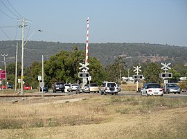
 Toodyay Road railway crossing, adjacent to Reid Highway, Stratton, Western Australia | |||||||||||||||
 | |||||||||||||||
| Coordinates | 31°51′54″S 116°02′20″E / 31.865°S 116.039°E | ||||||||||||||
| Population | 3,267 (SAL 2021)[1] | ||||||||||||||
| Postcode(s) | 6056 | ||||||||||||||
| LGA(s) | City of Swan | ||||||||||||||
| State electorate(s) | Midland | ||||||||||||||
| Federal division(s) | Hasluck | ||||||||||||||
| |||||||||||||||
Stratton is a mostly residential eastern suburb of Perth, Western Australia, located within the City of Swan. It was formerly known as Wexcombe; the name Stratton was chosen in 1989 to honour John Peter Stratton, a farmer, businessman and local landowner who was president of the Western Australian Trotting Association from 1930 until 1966.[2]
References
[edit]- ^ Australian Bureau of Statistics (28 June 2022). "Stratton (suburb and locality)". Australian Census 2021 QuickStats. Retrieved 28 June 2022.
- ^ "History of metropolitan suburb names – S". Western Australian Land Information Authority. Archived from the original on 16 March 2022. Retrieved 10 October 2008.
External links
[edit]![]() Media related to Stratton, Western Australia at Wikimedia Commons
Media related to Stratton, Western Australia at Wikimedia Commons
