Stierop
Appearance
Stierop | |
|---|---|
Hamlet | |
 | |
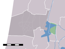
 The statistical district (lightgreen) of De Woude in the municipality of Castricum. Stierop lies at the south boundary of this district. | |
| Coordinates: 52°32′07″N 4°46′12″E / 52.53528°N 4.77000°E | |
| Country | Netherlands |
| Province | North Holland |
| Municipality | Castricum |
| Time zone | UTC+1 (CET) |
| • Summer (DST) | UTC+2 (CEST) |
Stierop is a hamlet in the Dutch province of North Holland. It is a part of the municipality of Castricum, and lies about 9 km south of Alkmaar. Until 1 January 2002, Stierop belonged to the municipality of Akersloot.
Stierop has about 20 inhabitants.[1]
References
[edit]

