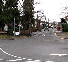
St John's, Lichfield
| St John's | |
|---|---|
 Shortbutts Lane, St John's, Lichfield | |
Location within Staffordshire | |
| Population | 5,924 (2021 Census Ward Profile) |
| • London | 123 mi (198 km) SE |
| Civil parish |
|
| District | |
| Shire county | |
| Region | |
| Country | England |
| Sovereign state | United Kingdom |
| Post town | Lichfield |
| Postcode district | WS14 |
| Dialling code | 01543 |
| Police | Staffordshire |
| Fire | Staffordshire |
| Ambulance | West Midlands |
| UK Parliament | |
St John's is a ward and suburb[1][2] of Lichfield in the Lichfield District and the ceremonial county of Staffordshire, England. It is one of the six wards on Lichfield City Council and as of September 2024[update] was represented by Cllrs Colin Greatorex (Con), Deb Baker (Con), Jeyan Anketell (Lab), John Smith (Lib Dem), Katie Farrelly (Lab) and Rosemary Harvey-Coggins (Lab).[3]
Geography
[edit]
St John's is located to the south of Lichfield City Centre and is close to the villages of Muckley Corner, Pipehill, Shenstone and Wall.[4] It is connected to Birmingham and Tamworth by the A5127 and A51 roads. Lichfield City and Shenstone railway stations are the closest railway stations on the Cross-City Line which passes through the area. Also nearby is the mothballed South Staffordshire Line to Walsall,[5] which is now part of the Fosseway Heath Avenue Wetlands.[6]
Demographics
[edit]At the 2021 census, the population of St John's ward profile was 7,276. Of the findings, the ethnicity and religious composition of the ward was:
| :St John's: 2021 Census[7] | |||||||||||||
| Ethnic group | Population | % | |||||||||||
|---|---|---|---|---|---|---|---|---|---|---|---|---|---|
| White | 5,540 | 93.5% | |||||||||||
| Asian or Asian British | 159 | 2.7% | |||||||||||
| Mixed | 150 | 2.6% | |||||||||||
| Black or Black British | 44 | 0.7% | |||||||||||
| Other Ethnic Group | 28 | 0.4% | |||||||||||
| Arab | 2 | 0.1% | |||||||||||
| Total | 5,924 | 100% | |||||||||||
The religious composition of St John's ward at the 2021 Census was recorded as:
| St John's: Religion: 2021 Census | |||||||||||||
| Religious | Population | % | |||||||||||
|---|---|---|---|---|---|---|---|---|---|---|---|---|---|
| Christian | 3,200 | 56.7% | |||||||||||
| Irreligious | 2,275 | 40.3% | |||||||||||
| Muslim | 73 | 1.3% | |||||||||||
| Sikh | 44 | 0.8% | |||||||||||
| Hindu | 19 | 0.3% | |||||||||||
| Other Religion | 18 | 0.3% | |||||||||||
| Buddhist | 12 | 0.2% | |||||||||||
| Jewish | 5 | 0.1% | |||||||||||
| Total | 5,924 | 100% | |||||||||||
References
[edit]- ^ Live, Lichfield (24 August 2024). "Developer agrees partnership to deliver affordable homes at Lichfield scheme". Lichfield Live®. Retrieved 8 September 2024.
- ^ Gilmore, Teresa (15 September 2024). Lichfield: A Potted History. Amberley Publishing Limited. ISBN 978-1-3981-0641-3. Retrieved 8 September 2024.
- ^ "Councillors - Lichfield City Council". www.lichfield.gov.uk. Retrieved 8 September 2024.
- ^ "st-johns-streetmap". www.lichfielddc.gov.uk. Retrieved 8 September 2024.
- ^ Live, Lichfield (2 May 2024). "Work begins to create Greenway along route of former railway line between Lichfield and Burntwood". Lichfield Live®. Retrieved 8 September 2024.
- ^ "Towpath Trail Page 46". lhcrt.org.uk. Retrieved 8 September 2024.
- ^ "St John's (Ward, United Kingdom) - Population Statistics, Charts, Map and Location". www.citypopulation.de. Retrieved 8 September 2024.

