St Paul's High School, Glasgow
Appearance
(Redirected from St. Paul's High School (Glasgow))
| Saint Paul's R.C. High School St Paul's | |
|---|---|
 | |
| Address | |
 | |
36 Damshot Road Glasgow Scotland | |
| Information | |
| Type | Comprehensive school |
| Motto | Aiming High for Young People |
| Religious affiliation(s) | Roman Catholic |
| Teaching staff | 70 |
| Enrollment | 1200 |
| Accreditation | Schools of Ambition |
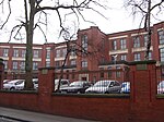
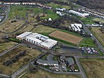
St Paul's High School is a co-educational, Roman Catholic, comprehensive secondary school located in Pollok, Glasgow, Scotland. It was built on the site of, and using some buildings from, the former Craigbank Secondary School, to replace the previous Catholic school in the area, Bellarmine Secondary (the Silverburn Centre is now at its location), opening with its new identity in 2002.[1]
The majority of the Pollok district falls into the catchment area of a different school, Lourdes Secondary, while St Paul's serves communities further south including Arden, Carnwadric, Darnley, Deaconsbank, Eastwood, Househillwood, Kennishead, Nitshill, Parkhouse and Priesthill.[2]
References
[edit]- ^ Project 2002 will upgrade city's schools, The Herald, 20 February 2001
- ^ Which School Catchment?, Glasgow City Council
External links
[edit]55°49′30″N 4°20′16″W / 55.82500°N 4.33778°W


