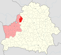
Smarhon District
Appearance
Smarhon District
| |
|---|---|
 | |
| Coordinates: 54°29′01″N 26°24′00″E / 54.48361°N 26.40000°E | |
| Country | Belarus |
| Region | Grodno Region |
| Administrative center | Smarhon |
| Government | |
| • Chairman | Henadzi Kharuzhyk |
| Area | |
• District | 1,490.01 km2 (575.30 sq mi) |
| Highest elevation | 320 m (1,050 ft) |
| Lowest elevation | 121 m (397 ft) |
| Population (2024)[1] | |
• District | 48,464 |
| • Density | 33/km2 (84/sq mi) |
| • Urban | 35,422 |
| • Rural | 13,042 |
| Website | smorgon |

Smarhon District or Smarhoń District[2] (Belarusian: Смаргонскі раён; Russian: Сморгонский район) is a district (raion) of Grodno Region in Belarus. The administrative center is Smarhon.[1] As of 2024, it has a population of 48,464.[1]
Historically the district's center Smarhon was part of the Vilnius Voivodeship within the Grand Duchy of Lithuania until 1795.[3] Forty percent of the names of Smarhon District's settlements have remained of Lithuanian origin, while residents of Smarhon once spoke in the Eastern Aukštaitian-Vilnian dialect of Lithuanian language.[3]
Main sights
[edit]Notable residents
[edit]- Adam Stankievič (1882, Arlianiaty village – 1949), Belarusian Roman Catholic priest, politician and writer, a Gulag prisoner[4]
- Jan Stankievič (1891, Arlianiaty village – 1976), Belarusian politician, linguist, historian and philosopher[5]
- Antoni Leszczewicz (1890, Abramaǔščyna – 1943), beautified Marian Father and Roman Catholic priest, victim of the Nazis[6]
- Andrei Tsikota (1891–1952), Belarusian priest, member of the Rada of the Belarusian Democratic Republic and a victim of the Gulag[7][8]
Notes
[edit]References
[edit]- ^ a b c "Численность населения на 1 января 2024 г. и среднегодовая численность населения за 2023 год по Республике Беларусь в разрезе областей, районов, городов, поселков городского типа". belsat.gov.by. Archived from the original on 2 April 2024. Retrieved 13 May 2024.
- ^ Official transliteration from Belarusian language (2007)
- ^ a b Garšva, Kazimieras. "Smurgainys". Visuotinė lietuvių enciklopedija (in Lithuanian). Retrieved 25 November 2024.
- ^ Biography of Father Adam Stankiewicz
- ^ Stankievič Jan
- ^ Антоні Ляшчэвіч (Antoni Leszczewicz) (in Belarusian)
- ^ Biography of Servant of God Archimandrite Andrzej Cikoto, MIC
- ^ Андрэй Цікота: святар, які ламаў стэрэатыпы [Andrei Tsikota: a priest who broke stereotypes] - Krynica.info


