Sipisopiso
Appearance
This article needs additional citations for verification. (October 2020) |
| Sipiso-piso Waterfall | |
|---|---|
| Sipiso-piso | |
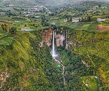
 Sipiso-piso waterfall drops from an opening on the rock face to the bottom | |
 | |
| Location | Tanah Karo Regency, North Sumatra, Indonesia |
| Coordinates | 2°54′59″N 98°31′11″E / 2.916416°N 98.519648°E |
| Type | Plunge |
| Total height | 120 metres (390 ft) |
| Watercourse | Pajanabolon River |

The Sipiso-piso is a plunge waterfall in the Batak highlands of Sumatra, Indonesia. It is formed by a small underground river of the Karo plateau that falls from a cave in the side of caldera of Lake Toba, some 120 metres (390 ft) down to lake level.[1] Sipiso-piso is a well-known tourist attraction and a nearby vantage point offers views of the falls and lake. There are 651 steps between the bottom of the waterfall and the main entrance.
Sipiso-piso waterfall is located in the Tanah Karo regency in North Sumatra, at the northernmost tip of the Lake Toba caldera, near the fishing village of Tongging.[1] The closest municipality is the town of Kabanjahe, about 25 km (16 mi) away,
References
[edit]- ^ a b Stephen Backshall (2003). Indonesia. Rough Guides Limited. p. 373. ISBN 9781858289915.
