Simpson Bay Lagoon
| Simpson Bay Lagoon | |
|---|---|
| Simson Bay Lagoon The Great Pond | |
 | |
| Coordinates | 18°03′07″N 63°06′32″W / 18.052°N 63.109°W |
| Primary outflows | Baie Nettlé Simson Bay |
| Ocean/sea sources | Caribbean sea |
| Basin countries | Saint Martin Sint Maarten |
| Designation | |
| Official name | Mullet Pond |
| Designated | 23 May 2014 |
| Reference no. | 2270[1] |
| Surface area | 1,250 hectares (3,100 acres) |
| Max. depth | 6 metres (20 ft) |
| Shore length1 | 4.48 kilometres (2.78 mi) |
| Islands | Grand îlet Little Key |
| 1 Shore length is not a well-defined measure. | |

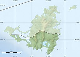
Simpson Bay Lagoon (also spelt Simson Bay Lagoon, or referred to simply as The Great Pond) is one of the largest inland lagoons in the West Indies of the Caribbean. It is located on the island of Saint Martin. The border between the French and Dutch halves of the island runs across the centre of the lagoon. There are two small islands that lie in the lagoon: the larger, Grand Ilet (also known as Explorer's Island) to the north, is within the French region of Saint-Martin; the smaller, Little Key, to the south, is on the Dutch Sint Maarten side.
The lagoon is connected to the Caribbean Sea via a small channel in the north-west which flows into Baie Nettlé in Saint-Martin and another small channel in the south-east which flows into Simson Bay in Sint Maarten. Sint Maarten's airport, Princess Juliana International Airport lies close to the lagoon's southern shore.
Environment
[edit]The protected waters of this lagoon provide significant seagrass and mangrove habitats, well known juvenile reef fish recruitment areas which likely feed the marine protected areas of Man of War Shoal Marine Park of St. Maarten and the Reserve Naturelle de Saint-Martin.[2]
Mullet Pond is a section of the Simpson Bay Lagoon which still contains a substantial portion of Red Mangroves Rhizophora mangle. It has been a protected Ramsar site since 2014.[1][3]
Studies have shown that land-based sewage wastewater entering the Lagoon has resulted in bacterial levels far exceeding acceptable norms. Research by Environmental Protection in the Caribbean (EPIC) on lagoon and watershed water quality has shown that enterococci bacterial levels exceeded allowable levels in 96% (n=26) of samples. Land-based sites were found to be more polluted than the Lagoon, indicating that a significant portion of contamination originates from the land and not just from boats.
With only two narrow channels which permit the flow of fresh water into this large body of water, certain urbanized areas of the lagoon, such as Cole Bay and Marigot, do not experience sufficient water flow to remove or dilute pollutants. High pollution areas therefore frequently exhibit murky or brown water with a foul odor and excessive algal growth and eutrophication.[4]
The presence of invasive species, such as the seagrass H. stipulacea, poses additional threats to the lagoon environment.[5]
Economy
[edit]St. Maarten's marine industry, centered around the Lagoon, represents 12.5% of the island economy, compared to 9.5% for the Hotel and Restaurant industry (Central Bureau of Statistics).[6] The calm waters of the lagoon make it a safe harbor for vessels seeking repairs, supplies, and protection from hurricanes. The megayacht charter industry is a conspicuous aspect of the yachting sector.
See also
[edit]References
[edit]- ^ a b "Mullet Pond". Ramsar Sites Information Service. Retrieved 25 April 2018.
- ^ Molenaar, Anne. "The socio-cultural value of the Simpson Bay Lagoon" (PDF). pp. 11–12. Retrieved 14 April 2023.
- ^ "Aquatic Areas|Protecting the Natural Areas of St. Maarten". Nature Foundation St. Maarten. 24 July 2018. Retrieved 14 April 2023.
- ^ van Slooten & Lips, Lester & Sietske. "Water Quality in the Simpson Bay Lagoon". unpublished technical report. Archived from the original on 2013-12-02. Retrieved 2013-11-23.
- ^ Bervoets, Tadzio. "Results of Nature Foundation Research into Invasive Seagrass H. Stipulacea in the Simpson Bay Lagoon" (PDF). unpublished technical report. Retrieved 2013-11-23.
- ^ Duijndam, Sem; van Beukering, Pieter; Fralikhina, Hanna; Molenaar, Anne; Koetse, Mark (August 2020). "Valuing a Caribbean coastal lagoon using the choice experiment method: The case of the Simpson Bay Lagoon, Saint Martin". Journal for Nature Conservation. 56. doi:10.1016/j.jnc.2020.125845. Retrieved 14 April 2023.


