Sauyr Zhotasy
| Sauyr Zhotasy | |
|---|---|
| Highest point | |
| Elevation | 3,840 m (12,600 ft)[1] |
| Prominence | 3,252 m (10,669 ft)[1] Ranked 68th |
| Listing | Ultra |
| Coordinates | 47°02′57″N 85°34′00″E / 47.04917°N 85.56667°E[1] |
| Geography | |
| Location | China–Kazakhstan border |
| Parent range | Saur, Tien Shan |
| Climbing | |
| First ascent | Unclimbed |
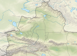
Sauyr Zhotasy (Kazakh: Сауыр жотасы, Sauyr jotasy), also known as Muz Tau (Chinese: 木斯岛山; pinyin: Mùsīdǎo Shān), at 3,840 m is the highest point in the Saur Range and of the entire Saur-Tarbagatai mountain system, part of the Tien Shan, on the border between Kazakhstan and China. It lies 100 kilometres (60 mi) southeast of Zaysan Lake. Despite its low elevation, it is well separated from higher ranges in its area (the Saur-Tarbagatai System being separated from the Altai Mountains by the Irtysh River valley, and from the Dzungarian Alatau, by the Dzungarian Gate); it is therefore ranked highly by topographic prominence.
There have been two documented ascents to sub-summits of Sauyr Zhotasy, occurring in 2017 and 2018 by Ed Hannam and his team,[2][3] but no official ascents to the main summit has been recorded.
See also
[edit]References
[edit]- ^ a b c "The Central Asian Republics: Ultra-Prominence Page". Peaklist.org. Retrieved 2014-05-26.
- ^ Hannam, Ed (2018). "Sauyr Zhotasy East, First Known Ascent". American Alpine Club. Retrieved 30 October 2020.
- ^ Hannam, Ed (2019). "Muz Tau (Sauyr Zhotasy), Attempt from the Northeast". The American Alpine Club. Retrieved 30 October 2020.
External links
[edit]


