Sarawak River
| Sarawak River Sungai Sarawak | |
|---|---|
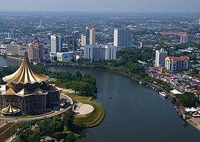
 The Sarawak River flowing through Kuching city centre. | |
 | |
| Location | |
| Country | Malaysia |
| Physical characteristics | |
| Source | Upper Kapuas Range |
| • location | Malaysia |
| Mouth | Muara Tebas |
• location | South China Sea, Malaysia |
• coordinates | 1°38′17″N 110°29′59″E / 1.6380°N 110.4996°E |
• elevation | 0 m (0 ft) |
| Length | 120 km (75 mi) |
| Basin size | 2,459 km2 (949 sq mi) |
| Basin features | |
| Tributaries | |
| • left | Sg. Sarawak Kiri |
| • right | Sg. Sarawak Kanan |
The Sarawak River (Malay: Sungai Sarawak) is a river in Sarawak, Malaysia. It is an important source of water and transportation for the inhabitants in southwestern Sarawak. The river is also used for water-related sport activities such as the annual Sarawak Regatta which attract tourists from all over the world.
Geography
[edit]
The Astana, the official residence of the Yang di-Pertua Negeri Sarawak (Governor of Sarawak) and the New Sarawak State Legislative Assembly Building is located on the north bank of the river as well as Fort Margherita.
It runs along Holiday Inn Kuching (now named Grand Margherita Hotel) and Riverbank Suites apartment near the river. The Sarawak River Cruise runs around it.
Archeology
[edit]There are six archeological sites in Santubong, located at the mouth of the river.[1]
See also
[edit]References
[edit]- ^ Gani, Nicholas (2019). The Sarawak River Part 1: An archeological perspective. Kuching: Kuching in and out (KINO) magazine. pp. 25 - 2o.
- MacKinnon K, Hatta G, Halim H, Mangalik A.1998. The ecology of Kalimantan. Oxford University Press, Australia.
