San Matéo River
Appearance
| San Matéo | |
|---|---|
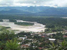
 San Matéo River and Espíritu Santo River (upper right) in Villa Tunari just before their confluence to Chapare River in the east of the town. | |
 | |
| Location | |
| Country | Bolivia |
| Region | Cochabamba Department |
| Municipality | Tiraque Province, Chapare Province |
| Physical characteristics | |
| Mouth | Chapare River |
• location | Villa Tunari |
• coordinates | 16°58′S 65°24′W / 16.967°S 65.400°W |
• elevation | 289 m (948 ft) |
| Basin features | |
| Tributaries | |
| • right | Ivirizu, Chillawara |
San Matéo is a Bolivian river in the Cochabamba Department, Tiraque Province and in the Chapare Province, Villa Tunari Municipality.[1] It belongs to the Amazon River watershed.
San Matéo River flows to Villa Tunari in a northeasterly direction. Shortly before reaching the town it receives waters from its most important tributary, the Ivirizu River, which comes from the south. In the east of Villa Tunari, in the department of Cochabamba, San Matéo River meets Espíritu Santo River coming from the west. From the point of the confluence, the river is known as Chapare River.
References
[edit]- ^ Villa Tunari Municipality: population data and map showing San Matéo River south of Villa Tunari on the border with Tiraque Province
- lib.utexas.edu Detailed map of the area
External links
[edit]![]() Media related to Rio San Matéo at Wikimedia Commons
Media related to Rio San Matéo at Wikimedia Commons

