San Francisco, Antioquia
Appearance
San Francisco | |
|---|---|
Municipality and town | |
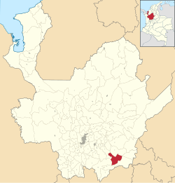
 Location of the municipality and town of San Francisco in the Antioquia Department of Colombia | |
| Coordinates: 5°57′51″N 75°6′6″W / 5.96417°N 75.10167°W | |
| Country | |
| Department | |
| Subregion | Eastern |
| Elevation | 1,250 m (4,100 ft) |
| Population (2015) | |
• Total | 5,318 |
| [1] | |
| Time zone | UTC-5 (Colombia Standard Time) |
| Website | [1] |
San Francisco is a town and municipality in Antioquia Department, Colombia. It is part of the subregion of Eastern Antioquia. In 2015, the population comprised 5,318 people.
History
[edit]San Francisco was previously known as El Morrón.
It was founded in 1830 as part of the municipality of Cocorná. In February 1986 was established as a municipality with the name of San Francisco, in memory of Saint Francis of Assisi.
Climate
[edit]San Francisco has a tropical rainforest climate (Af). It has very heavy rainfall year-round.
| Climate data for San Francisco, Antioquia, elevation 1,306 m (4,285 ft), (1981–2010) | |||||||||||||
|---|---|---|---|---|---|---|---|---|---|---|---|---|---|
| Month | Jan | Feb | Mar | Apr | May | Jun | Jul | Aug | Sep | Oct | Nov | Dec | Year |
| Mean daily maximum °C (°F) | 25.9 (78.6) |
26.0 (78.8) |
25.8 (78.4) |
25.9 (78.6) |
26.0 (78.8) |
26.1 (79.0) |
26.3 (79.3) |
26.4 (79.5) |
26.0 (78.8) |
25.8 (78.4) |
25.6 (78.1) |
25.8 (78.4) |
26.0 (78.8) |
| Daily mean °C (°F) | 21.7 (71.1) |
21.8 (71.2) |
21.7 (71.1) |
21.8 (71.2) |
21.8 (71.2) |
22.0 (71.6) |
22.0 (71.6) |
21.9 (71.4) |
21.7 (71.1) |
21.5 (70.7) |
21.5 (70.7) |
21.7 (71.1) |
21.8 (71.2) |
| Mean daily minimum °C (°F) | 17.2 (63.0) |
17.5 (63.5) |
17.5 (63.5) |
17.4 (63.3) |
17.4 (63.3) |
17.3 (63.1) |
17.1 (62.8) |
17.0 (62.6) |
17.0 (62.6) |
17.0 (62.6) |
17.1 (62.8) |
17.3 (63.1) |
17.2 (63.0) |
| Average precipitation mm (inches) | 292.2 (11.50) |
286.6 (11.28) |
379.5 (14.94) |
493.9 (19.44) |
525.3 (20.68) |
346.1 (13.63) |
339.5 (13.37) |
427.3 (16.82) |
584.9 (23.03) |
610.9 (24.05) |
572.9 (22.56) |
374.8 (14.76) |
5,234 (206.1) |
| Average precipitation days (≥ 1.0 mm) | 17 | 17 | 20 | 23 | 23 | 19 | 18 | 20 | 23 | 25 | 25 | 21 | 249 |
| Average relative humidity (%) | 89 | 89 | 89 | 89 | 89 | 89 | 88 | 88 | 90 | 90 | 90 | 90 | 89 |
| Source: Instituto de Hidrologia Meteorologia y Estudios Ambientales[2] | |||||||||||||
Demographics
[edit]Total Population: 5 318 people. (2015)[1]
- Urban Population: 2 446
- Rural Population: 2 872
Literacy Rate: 75.5% (2005)[3]
- Urban Areas: 77.9%
- Rural Areas: 74.2%
References
[edit]- ^ a b "Resultados y proyecciones (2005-2020) del censo 2005". DANE. May 1, 2015.
- ^ "Promedios Climatológicos 1981–2010" (in Spanish). Instituto de Hidrologia Meteorologia y Estudios Ambientales. Archived from the original on 15 August 2016. Retrieved 3 June 2024.
- ^ Censo oficial DANE 2005, Perfiles Departamentos y Municipios Archived 2008-07-26 at the Wayback Machine


