Sakaraha
Sakaraha | |
|---|---|
 | |
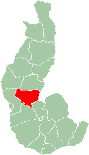
 Map of former Toliara Province showing the location of Sakaraha (red). | |
| Country | Madagascar |
| Region | Atsimo-Andrefana |
| District | Sakaraha |
| Population (2018)Census | |
• Total | 31,183 |
| Postal code | 620 |
Sakaraha is a rural municipality in Atsimo-Andrefana Region, south-western Madagascar. It has a population of 31,183 in 2018.

Geography
[edit]Sakaraha is situated along route nationale No. 7 (Tuléar-Fianarantsoa) at 134 km from Tuléar, 64 km from Andranovory and 84 km from Ilakaka.[1] It is situated at the Zombitse-Vohibasia National Park.
Economy
[edit]Mining: there are sapphires found in the town of Sakaraha.
Natural gas was discovered near Sakaraha by Madagascar Southern Petroleum Company (MSCP) in 2011.[2] There are also some oil deposits near Sakaraha but there is no commercial exploration.[3]
On 31 January 2007, Saudi terrorist Mohammed Jamal Khalifa was murdered by 25 to 30 armed men while visiting a gemstone mine he owned in Sakamilko, near the town of Sakaraha. He had recently called in local police to evict people who had been working the gem mine in his absence. Though all his belongings had been stolen there is some conjecture that the death was politically motivated.[4][5] Khalifa's family came to believe that he was assassinated by operators from the Joint Special Operations Command.[6][7]
References
[edit]- ^ Atlas Mondial, France Loisir, page 159
- ^ (in French) L'express de Madagascar - 8 September 2011 Archived 14 December 2013 at the Wayback Machine
- ^ (in French) Jacaranda.fr
- ^ "Bin Laden brother-in-law shot dead in Madagascar" Philippine Daily Inquirer Archived 18 June 2008 at the Wayback Machine accessed on 31 January 2007
- ^ "Gems, al-Qaida and Murder: Mystery over killing of Osama Bin Laden's friend" The Guardian World news section accessed on 31 January 2007
- ^ "Bin Laden brother-in-law shot dead in Madagascar" Philippine Daily Inquirer Archived 18 June 2008 at the Wayback Machine accessed on 31 January 2007
- ^ "Gems, al-Qaida and Murder: Mystery over killing of Osama Bin Laden's friend" The Guardian World news section accessed on 31 January 2007

22°55′0″S 44°32′59″E / 22.91667°S 44.54972°E

