Sainte-Anne-de-la-Pocatière
Appearance
(Redirected from Sainte-Anne-de-la-Pocatiere, Quebec)
Sainte-Anne-de-la-Pocatière | |
|---|---|
 | |
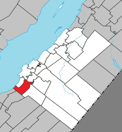
 Location within Kamouraska RCM | |
| Coordinates: 47°21′N 70°00′W / 47.350°N 70.000°W[1] | |
| Country | |
| Province | |
| Region | Bas-Saint-Laurent |
| RCM | Kamouraska |
| Constituted | July 1, 1855 |
| Named for | seigneury of la Pocatière[1] |
| Government | |
| • Mayor | Jean-François Pelletier |
| • Federal riding | Montmagny—L'Islet—Kamouraska—Rivière-du-Loup |
| • Prov. riding | Côte-du-Sud |
| Area | |
• Total | 79.70 km2 (30.77 sq mi) |
| • Land | 54.78 km2 (21.15 sq mi) |
| Population | |
• Total | 1,597 |
| • Density | 29.2/km2 (76/sq mi) |
| • Pop 2016-2021 | |
| • Dwellings | 717 |
| Time zone | UTC−5 (EST) |
| • Summer (DST) | UTC−4 (EDT) |
| Postal code(s) | |
| Area code(s) | 418 and 581 |
| Highways | |
| Website | www |
Sainte-Anne-de-la-Pocatière (French pronunciation: [sɛ̃t an də la pɔkatjɛʁ]) is a parish municipality in the Canadian province of Quebec, located in the Kamouraska Regional County Municipality.
Demographics
[edit]In the 2021 Census of Population conducted by Statistics Canada, Sainte-Anne-de-la-Pocatière had a population of 1,597 living in 681 of its 717 total private dwellings, a change of -2.4% from its 2016 population of 1,636. With a land area of 54.78 km2 (21.15 sq mi), it had a population density of 29.2/km2 (75.5/sq mi) in 2021.[4]
| Year | Pop. | ±% |
|---|---|---|
| 1861 | 3,406 | — |
| 1871 | 3,134 | −8.0% |
| 1881 | 2,878 | −8.2% |
| 1891 | 2,734 | −5.0% |
| 1901 | 2,434 | −11.0% |
| 1911 | 2,412 | −0.9% |
| 1921 | 2,885 | +19.6% |
| 1931 | 3,063 | +6.2% |
| 1941 | 3,368 | +10.0% |
| 1951 | 3,660 | +8.7% |
| 1956 | 4,073 | +11.3% |
| 1961 | 1,173 | −71.2% |
| 1966 | 1,274 | +8.6% |
| 1971 | 1,007 | −21.0% |
| 1976 | 1,112 | +10.4% |
| 1981 | 1,566 | +40.8% |
| 1986 | 1,758 | +12.3% |
| 1991 | 1,983 | +12.8% |
| 1996 | 1,862 | −6.1% |
| 2001 | 1,889 | +1.5% |
| 2006 | 1,843 | −2.4% |
| 2011 | 1,717 | −6.8% |
| 2016 | 1,636 | −4.7% |
| 2021 | 1,597 | −2.4% |
Government
[edit]- Mayor: Jean-François Pelletier
- Councillors: Sylvain Dorion, Carole Lévesque, Pascale G. Malenfant, Josée Michaud, Natasha Pelletier, Annie Sénéchal
Notable people
[edit]- Marie-Claude Bourbonnais, glamour model
See also
[edit]References
[edit]- ^ a b "Banque de noms de lieux du Québec: Reference number 56030". toponymie.gouv.qc.ca (in French). Commission de toponymie du Québec.
- ^ a b "Répertoire des municipalités: Geographic code 14090". www.mamh.gouv.qc.ca (in French). Ministère des Affaires municipales et de l'Habitation.
- ^ a b "Census Profile, 2021 Census, Statistics Canada - Validation Error".
- ^ "Population and dwelling counts: Canada, provinces and territories, and census subdivisions (municipalities), Quebec". Statistics Canada. February 9, 2022. Retrieved August 29, 2022.
- ^ Statistics Canada: 1996, 2001, 2006, 2011, 2016, 2021 census
External links
[edit] Media related to Sainte-Anne-de-la-Pocatière at Wikimedia Commons

