Saint-René-de-Matane
Saint-René-de-Matane | |
|---|---|
 Jean-Chassé covered bridge | |
| Motto(s): Agriculture, Nature, Sylviculture ("Agriculture, Nature, Forestry") | |
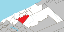
 Location within La Matanie RCM | |
| Coordinates: 48°42′N 67°23′W / 48.700°N 67.383°W[1] | |
| Country | Canada |
| Province | Quebec |
| Region | Bas-Saint-Laurent |
| RCM | La Matanie |
| Constituted | December 18, 1982 |
| Government | |
| • Mayor | Rémi Fortin |
| • Federal riding | Haute-Gaspésie—La Mitis—Matane—Matapédia |
| • Prov. riding | Matane-Matapédia |
| Area | |
• Total | 258.29 km2 (99.73 sq mi) |
| • Land | 253.89 km2 (98.03 sq mi) |
| Population | |
• Total | 961 |
| • Density | 3.8/km2 (10/sq mi) |
| • Pop (2016-21) | |
| • Dwellings | 596 |
| Time zone | UTC−5 (EST) |
| • Summer (DST) | UTC−4 (EDT) |
| Postal code(s) | |
| Area code(s) | 418 and 581 |
| Highways | |
| Website | www |
Saint-René-de-Matane (French pronunciation: [sɛ̃ ʁəne də matan]) is a municipality in Quebec, Canada.
In addition to main population centre of Saint-René located along Quebec Route 195, the municipality also includes the communities of Le Renversé, Rivière-Matane, Ruisseau-Gagnon, and Village-à-Dancause.
History
[edit]The Municipality of Saint-René-de-Matane was formed on December 18, 1982, through the merger of the Parish Municipalities of Saint-René-de-Matane and Saint-Nil, founded in 1965 and 1974 respectively. Its name comes from René Goupil, a Canadian martyr canonized in 1930.[1]
Geography
[edit]Saint-René-de-Matane is located on the southern slope of the St. Lawrence River, 430 kilometres (270 mi) northeast of Quebec City and 110 kilometres (68 mi) northeast of Rimouski. Major cities near Saint-René-de-Matane are Matane, 25 kilometres (16 mi) to the north, Sayabec, 35 kilometres (22 mi) to the west, Amqui, 35 kilometres (22 mi) and Causapscal, 55 kilometres (34 mi) to the south. The municipality is located on Route 195, which connects Matane to Amqui, between Saint-Vianney to the south and Matane to the north. This road runs along the Matane River in its section crossing the municipality. The territory of the municipality, covering an area of 256 square kilometres (99 sq mi), also includes the Petite rivière Matane and the Gagnon stream.[1]
The municipality of Saint-René-de-Matane is part of La Matanie Regional County Municipality in the administrative region of Bas-Saint-Laurent. In addition to the main hamlet of Saint-René, the municipality is made up of four hamlets: Le Renversé, Rivière-Matane, Ruisseau-Gagnon and Village-à-Dancause.[2]
Demographics
[edit]Population
[edit]| 2021 | 2016 | 2011 | |
|---|---|---|---|
| Population | 961 (-3.0% from 2016) | 991 (-9.0% from 2011) | 1,089 (+1.8% from 2006) |
| Land area | 253.89 km2 (98.03 sq mi) | 255.26 km2 (98.56 sq mi) | 255.39 km2 (98.61 sq mi) |
| Population density | 3.8/km2 (9.8/sq mi) | 3.9/km2 (10/sq mi) | 4.3/km2 (11/sq mi) |
| Median age | 54.4 (M: 56.0, F: 52.4) | 51.9 (M: 53.4, F: 49.6) | 48.1 (M: 48.6, F: 46.9) |
| Private dwellings | 596 (total) 478 (occupied) | 659 (total) 468 (occupied) | 639 (total) |
| Median household income | $56,800 | $47,232 | $39,263 |
|
| ||||||||||||||||||||||||||||||
| 2016 Population based on revised count. Population counts are not adjusted for boundary changes. Source: Statistics Canada[10] | |||||||||||||||||||||||||||||||
Mother tongue:
- English as first language: 0%
- French as first language: 99.5%
- English and French as first language: 0.5%
- Other as first language: 0%
Government
[edit]List of former mayors:[11]
- Jean Yves Murray (1982–1992)
- Colombe Canuel Lagacé (1992–2000)
- Jean Charles Gagnon (2000–2009)
- Sylvain Audit (2009–2011)
- Roger Vaillancourt (2011–2015)
- Harold Chassé (2015–2017)
- Rémi Fortin (2017–present)
See also
[edit]References
[edit]- ^ a b c "Banque de noms de lieux du Québec: Reference number 137702". toponymie.gouv.qc.ca (in French). Commission de toponymie du Québec.
- ^ a b c "Répertoire des municipalités: Geographic code 08035". www.mamh.gouv.qc.ca (in French). Ministère des Affaires municipales et de l'Habitation. Retrieved 2024-09-05.
- ^ a b "Saint-René-de-Matane (Code 2408035) Census Profile". 2021 census. Government of Canada - Statistics Canada. Retrieved 2024-09-05.
- ^ "Population and dwelling count amendments, 2016 Census". www12.statcan.gc.ca. Government of Canada - Statistics Canada. Retrieved 5 September 2024.
- ^ "2021 Community Profiles". 2021 Canadian census. Statistics Canada. February 4, 2022. Retrieved 2022-04-27.
- ^ "2016 Community Profiles". 2016 Canadian census. Statistics Canada. August 12, 2021. Retrieved 2022-11-02.
- ^ "2011 Community Profiles". 2011 Canadian census. Statistics Canada. March 21, 2019. Retrieved 2013-05-19.
- ^ "2006 Community Profiles". 2006 Canadian census. Statistics Canada. August 20, 2019.
- ^ "2001 Community Profiles". 2001 Canadian census. Statistics Canada. July 18, 2021.
- ^ 1996, 2001, 2006, 2011, 2016, 2021 census
- ^ "Répertoire des entités géopolitiques: Saint-René-de-Matane (municipalité) 18.12.1982 - ..." www.mairesduquebec.com. Institut généalogique Drouin. Retrieved 5 September 2024.

