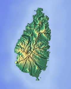
Roseau River (Saint Lucia)
Appearance
| Roseau River La Grande Riviere | |
|---|---|
| Location | |
| Country | Saint Lucia |
| Region | Anse-la-Raye Quarter |
| Physical characteristics | |
| Mouth | Roseau Bay, Caribbean Sea |
• location | west of Roseau, Saint Lucia |
• coordinates | 13°57′36″N 61°01′57″W / 13.959965°N 61.032363°W |
The Roseau River is a river in the Anse-la-Raye Quarter of the island country of Saint Lucia. It flows north and then west from the central highlands in the south of the island, reaching the Caribbean Sea to the north of the town of Anse la Raye. The Roseau river is also the longest in the country and is dammed by the John Compton Dam near Millet.[1][2][3]
See also
[edit]References
[edit]- ^ "Esperance River". National Geospatial Intelligence Agency GeoNames. Retrieved August 3, 2021.
- ^ "Integrating the Management of Watersheds and Coastal Areas in St. Lucia". Water Resources Management Unit, Ministry of Agriculture, Forestry and Fisheries Government of St. Lucia. 2001. Retrieved August 3, 2021.
- ^ Breen, Henry H. (1844). St. Lucia: Historical, Statistical, and Descriptive. London: Longman, Brown, Green, and Longmans. p. 10.
- Higgins, Chris (2001). St. Lucia. Montreal: Ulysses Travel Guides. ISBN 2-89464-396-9.

