Rivière des Pluies
Appearance
| Rivière des Pluies | |
|---|---|
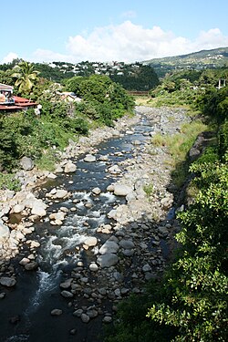
 Rivière-des-Pluies below the Desbassyns bridge | |
 | |
| Location | |
| Country | France |
| Region | Réunion |
| Physical characteristics | |
| Mouth | Indian Ocean |
• coordinates | 20°52′58″S 55°30′8″E / 20.88278°S 55.50222°E |
| Length | 18.5 km (11.5 mi) |
The Rivière des Pluies is a river on the Indian Ocean island of Réunion. It flows to the sea on the island's northern shore, between the communes of Saint-Denis and Sainte-Marie. It is 18.5 km (11.5 mi) long.[1]
It gives its name to a district of Sainte-Marie that overlooks the river, and is inhabited by many people working in the capital.
River crossings
[edit]Rivière des Pluies is crossed by five bridges, from upstream to downstream.[2][better source needed]
- A bridge carrying a water supply canal.
- Desbassyns bridge, a road bridge carrying the main road 45.
- The Pont Neuf, a road bridge carrying the highway 102.
- A road bridge on Route Nationale 6, the most recent.
- A road bridge on the highway 2.
References
[edit]
