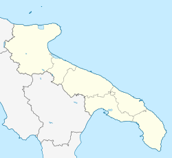
Rignano Garganico
Appearance
Rignano Garganico | |
|---|---|
| Comune di Rignano Garganico | |
| Coordinates: 41°41′N 15°35′E / 41.683°N 15.583°E | |
| Country | Italy |
| Region | Apulia |
| Province | Foggia (FG) |
| Government | |
| • Mayor | Luigi Di Fiore |
| Area | |
• Total | 89.4 km2 (34.5 sq mi) |
| Elevation | 590 m (1,940 ft) |
| Population (28 February 2017)[2] | |
• Total | 2,033 |
| • Density | 23/km2 (59/sq mi) |
| Demonym | Rignanesi |
| Time zone | UTC+1 (CET) |
| • Summer (DST) | UTC+2 (CEST) |
| Postal code | 71010 |
| Dialing code | 0882 |
| Patron saint | St. Roch |
| Saint day | 16 August |
| Website | Official website |
Rignano Garganico is a town and comune of the province of Foggia in the Apulia region of southern Italy.
Geography
[edit]Apricena, Foggia, San Marco in Lamis, San Severo and San Giovanni Rotondo are neighbouring towns. In 2017, migrants were removed from a refugee camp setup in Rignano Garganico.[3]
Main sights
[edit]- Paglicci Cave and the annexed museum
References
[edit]- ^ "Superficie di Comuni Province e Regioni italiane al 9 ottobre 2011". Italian National Institute of Statistics. Retrieved 16 March 2019.
- ^ All demographics and other statistics from the Italian statistical institute (Istat)
- ^ "Shame Is Keeping Us Here, Say African Migrants in Italy". The Wire. Retrieved 2018-11-20.


