
Ricciolo d'Italia
41°54′13″N 12°27′23″E / 41.90361°N 12.45639°E
Curl of Italy
Ricciolo d'Italia | |
|---|---|
| Footpath | |
 The Ricciolo d'Italia | |
| Location | Rome, Italy |
 Click on the map for a fullscreen view | |
| Coordinates: 41°54′12″N 12°27′25″E / 41.90329°N 12.45683°E | |
Ricciolo d'Italia (lit. 'the Curl of Italy') is a narrow portion of Italian territory that extends in a curve along the northern edge of St. Peter's Square in Rome.[1] Surrounded by Vatican City to the north and south, the Ricciolo d'Italia is a geographic salient with a characteristic curling shape and a width of only about 3 meters.[1] It was formed with the creation of the Vatican itself, by the signing of the Lateran Treaty between the Holy See and Kingdom of Italy on February 11, 1929,[2][1] ratified on[3] and effective from June 7 of that year.[4]
Description
[edit]

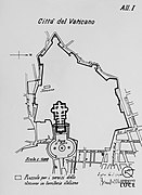
The Ricciolo d'Italia begins near the Porta Angelica, on the boundary that follows the Leonine Wall to just before the Bernini colonnade in St. Peter's Square. It curls westward just behind the northern arm of the colonnade.[5] The exact line is marked on the ground by a curved travertine line. It is 3 meters in width, with a length of about 60 meters,[1] and has a semicircular shape. The extreme tip is near the Apostolic Palace.
This strip of Italian soil is mistakenly considered, both because of the incongruity of the situation and for practical reasons, to be part of Vatican territory. Even Italian police forces and Swiss guards stationed there are said to consider the strip as belonging to the Vatican. The curl is freely accessible only in the initial, unfenced part.[1]
Several structures—whose view is limited by their close proximity to the colonnade of St. Peter's—overlook the curl. They include the Church of Saints Martin and Sebastian of the Swiss, the Porta San Pellegrino, the Vatican post office, and the Apostolic Palace.[6][7]
History
[edit]Article 3 of the Lateran Pacts states generically that "The boundaries of said [Vatican] City are indicated on the Plan which constitutes Annex I° of the present Treaty, of which it forms an integral part." The same article also states that when the Holy See intends to hold particular functions in St. Peter's Square, the Italian authorities must withdraw beyond the outer lines of the Bernini colonnade and its extension. Article 15 of the treaty confirms that extraterritoriality does not extend to the areas adjacent to the colonnade.[8]
The 1:5000 scale map attached to the Lateran Pacts, signed by Benito Mussolini and Cardinal Pietro Gasparri, is not particularly detailed and in some places there are small differences between the cartography published in the Official Gazette[9] and the Acta Apostolicae Sedis.[10] However, the official map attached to the Lateran Pacts does depict the area as part of Italy.[1]
For this reason, lacking a precise description of the borders, a bilateral Italian-Vatican commission was formed to verify precisely the boundaries between the two states; however, after three years of work, the conclusions reached in 1932 were no longer ratified. Since this commission had only an advisory purpose, the Italian government did not recognize any legal significance to this dispute. However, in some cases customs have since been consolidated over time.[11]
In the past, the Metropolitan City of Rome Capital considered the area as belonging to the Vatican, thus failing to issue a license to the wayside shrine located next to the Porta Angelica.[12] The curl, however, appears to be included in the georeferenced map of municipal boundaries, but not in the cadastral map.[13]
-
 Original of the Lateran Pacts
 -
 Map in the Official Gazette
 -
 Map on the Acta Apostolicae Sedis
.jpg)
.jpg)
.jpg)
References
[edit]Citation notes
[edit]- ^ a b c d e f "La città del Vaticano" [The Vatican City]. www.inftub.com. Archived from the original on July 10, 2023. Retrieved 2025-03-25.
- ^ Vito La Colla. "10 cose curiose e poco note sulla Città del Vaticano". Corriere della sera. Retrieved 24 May 2020.
- ^ Ekpo, Anthony (2024). The Roman Curia: History, Theology, and Organization. Washington, DC: Georgetown University Press. p. 8. ISBN 978-1-64712-436-6.
- ^ "Lateran Treaty". Encyclopedia Britannica. Archived from the original on 18 March 2025. Retrieved 2025-03-25.
- ^ Aldo Maria Valli. Piccolo mondo vaticano. Roma: Gius.Laterza & Figli Spa. Retrieved 24 May 2020.
- ^ "Mappa del Vaticano". 24timezones. Retrieved 24 May 2020.
- ^ "Mappa e cartina dei monumenti città del vaticano". mapparoma360. Retrieved 2020-05-24.
- ^ "Inter Sanctam Sedem et Italiae Regnum Conventiones". 1929-11-02.
- ^ "Legge 24 giugno 1929, n. 810, "Esecuzione del Trattato, dei quattro allegati annessi e del Concordato, sottoscritti in Roma, fra la Santa Sede e l'Italia, l'11 febbraio 1929 - VII"". Gazzetta Ufficiale del Regno d'Italia (130 bis): 6. 1929-06-05.
- ^ Eugenio Bonanata; Giovanni Orsenigo (2019-02-11). "Patti Lateranensi: l'entrata in vigore degli accordi". Vatican News.
- ^ Aldo Maria Valli (2013). Piccolo mondo vaticano. Roma-Bari: Gius.Laterza & Figli Spa. pp. 29–30.
- ^ Cesare Maffi (2019-07-13). "I confini confusi del Vaticano". Italia Oggi. No. 164. p. 10.
- ^ "Cartografia". Geo Portale del Comune di Roma. Retrieved 2020-05-27.