Reykhólahreppur
Appearance
This article needs additional citations for verification. (December 2009) |
Reykhólahreppur | |
|---|---|
 Skyline of Reykhólahreppur | |
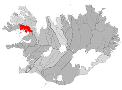
 Location of Reykhólahreppur | |
| Coordinates: 65°26′46″N 22°12′29″W / 65.44611°N 22.20806°W | |
| Country | Iceland |
| Region | Westfjords |
| Constituency | Northwest Constituency |
| Government | |
| • Manager | Ingibjörg Birna Erlingsdóttir |
| Area | |
• Total | 1,090 km2 (420 sq mi) |
| Population | |
• Total | 271 |
| • Density | 0.25/km2 (0.6/sq mi) |
| Postal code(s) | 380 |
| Municipal number | 4502 |
| Website | reykholar |
Reykhólahreppur (Icelandic pronunciation: [ˈreikˌhouːlaˌr̥ɛhpʏr̥] ⓘ) is a municipality in the Westfjords, Iceland. Its major settlement is Reykhólar.


