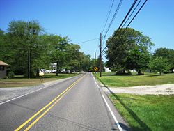
Retreat, New Jersey
Retreat, New Jersey | |
|---|---|
 Along Big Hill Road | |
| Coordinates: 39°54′59″N 74°42′46″W / 39.91639°N 74.71278°W | |
| Country | |
| State | |
| County | Burlington |
| Township | Southampton |
| Elevation | 9 m (30 ft) |
| Time zone | UTC−05:00 (Eastern (EST)) |
| • Summer (DST) | UTC−04:00 (Eastern (EDT)) |
| Area code | 609 |
| GNIS feature ID | 879666[1] |
Retreat is an unincorporated community and former hamlet located within Southampton Township in Burlington County, in the U.S. state of New Jersey.[2][3] The area consists of some residential houses grouped together along Big Hill Road and Retreat Road. A large cranberry bog exists to the southeast of the community while Leisuretowne retirement community is located southwest of here. Most of the remaining area consists of forestland.[4]
The community was originally named New Retreat during the American Revolutionary War by a Continental Army soldier who used the site for a cannonball manufacturing. The site was concealed from the British army who at the time was occupying present-day Mount Holly. Retreat was later home to cotton mills which operated until the 1840s.[5]
References
[edit]- ^ U.S. Geological Survey Geographic Names Information System: Retreat, New Jersey
- ^ Locality Search, State of New Jersey. Accessed June 9, 2016.
- ^ U.S. Geological Survey (1893). Bulletin - United States Geological Survey, Issues 111-121. The Survey. Retrieved October 7, 2011.
- ^ "Aerial view of Retreat" (Map). Google Maps. Retrieved June 17, 2016.
- ^ Shaw, W.H. (1883). "Southampton Township: Villages & Hamlets - Red Lion, Beaveville, & Retreat". Woodward and Hageman. The Preservation Commission of Historic Southampton. Archived from the original on March 4, 2016. Retrieved June 17, 2016.


