Reitsum
Reitsum | |
|---|---|
Village | |
 Reitsum church | |
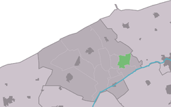
 Location in the former Ferwerderadiel municipality | |
| Coordinates: 53°19′15″N 5°53′23″E / 53.32083°N 5.88972°E | |
| Country | |
| Province | |
| Municipality | Noardeast-Fryslân |
| Area | |
• Total | 2.81 km2 (1.08 sq mi) |
| Elevation | 0.7 m (2.3 ft) |
| Population (2021)[1] | |
• Total | 125 |
| • Density | 44/km2 (120/sq mi) |
| Postal code | 9175[1] |
| Dialing code | 0519 |
Reitsum is a village in Noardeast-Fryslân municipality in the province of Friesland, the Netherlands. It had a population of around 133 in January 2017.[3] Before 2019, the village was part of the Ferwerderadiel municipality.[4]
History
[edit]The village was first mentioned between 822 and c. 825 as in Richeim. The etymology is unclear.[5] Reitsum is a terp (artificial living mound) village dating several centuries before Christ. It is one of the four so-called Vlieterpen (literally: flee terps) with a church and a couple of houses.[6] The nearby farmers and their cattle could take shelter on the mound in case of high water.[4]
The Dutch Reformed church was built in 1738. A tower was added and the church was enlarged in 1874.[6] In 1861, Johannes Ploos van Amstel became a minister of the church. On 10 February 1886, Ploos van Amstel announced as one of the first that he supported Abraham Kuyper which led to the 1886 Dutch Reformed Church split. Even though Ploos van Amstel was formally dismissed,[4] and a lock was installed on the pulpit, he continued to preach in the village.[7][4]
In 1840, Reitsum was home to 88 people.[4] Most of the terp was excavated in the late-19th century.[6]

References
[edit]- ^ a b c "Kerncijfers wijken en buurten 2021". Central Bureau of Statistics. Retrieved 1 April 2022.
- ^ "Postcodetool for 9175GB". Actueel Hoogtebestand Nederland (in Dutch). Het Waterschapshuis. Retrieved 1 April 2022.
- ^ Aantal inwoners per woonplaats in Ferwerderadiel op 1 januari 2017 - Ferwerderadiel
- ^ a b c d e "Reitsum". Plaatsengids (in Dutch). Retrieved 1 April 2022.
- ^ "Reitsum - (geografische naam)". Etymologiebank (in Dutch). Retrieved 1 April 2022.
- ^ a b c Ronald Stenvert & Sabine Broekhoven (2000). "Reitsum" (in Dutch). Zwolle: Waanders. ISBN 90 400 9476 4. Retrieved 1 April 2022.
- ^ "Het mysterie van Reitsum". Trouw (in Dutch). 5 June 2004. Retrieved 1 April 2022.
External links
[edit]![]() Media related to Reitsum at Wikimedia Commons
Media related to Reitsum at Wikimedia Commons


