
Ręczyn
Ręczyn | |
|---|---|
Village | |
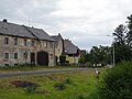
.jpg) House by the road | |
 Ręczyn | |
| Coordinates: 51°2′N 14°58′E / 51.033°N 14.967°E | |
| Country | |
| Voivodeship | Lower Silesian |
| County | Zgorzelec |
| Gmina | Zgorzelec |
| Population | 363 |
Ręczyn (German: Reutnitz; Upper Sorbian: Rěčyn) is a village in the administrative district of Gmina Zgorzelec, within Zgorzelec County, Lower Silesian Voivodeship, in south-western Poland, close to the German border.[1] It lies approximately 14 km (9 mi) south of Zgorzelec, and 146 km (91 mi) west of the regional capital Wrocław.
Gallery
[edit]-
 Children playground
 -
 Centre of the village
 -
 Old houses


References
[edit]- ^ "Główny Urząd Statystyczny" [Central Statistical Office] (in Polish). Select Miejscowości (SIMC) tab, select fragment (min. 3 znaki), enter town name in the field below, click WYSZUKAJ (Search)
Wikimedia Commons has media related to Ręczyn.
| Villages |  | |
|---|---|---|
| Seat (not part of the gmina) | ||
This Zgorzelec County location article is a stub. You can help Wikipedia by expanding it. |