Punta Sal
Appearance
Punta Sal | |
|---|---|
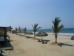
 A beach in Punta Sal | |
| Coordinates: 3°58′50″S 80°58′30″W / 3.98056°S 80.97500°W | |
| Country | |
| Region | Tumbes |
| Province | Contralmirante Villar |
| District | Canoas de Punta Sal |
| Government | |
| • Mayor | Reynaldo López Cruz (2019-2022) |
| Time zone | UTC-5 (PET) |
Punta Sal is a coastal village located along the Pacific Ocean in the region of Tumbes, northern Peru.[1] Due to its more equatorial location, the current of El Niño warms the surrounding sea and the local climate.[1] Punta Sal's ample beaches, with whitish sands and blue warm waters have made this area a popular beach resort.[1]
Geography
[edit]Punta Sal is considered the longest beach in the northern Peruvian coast.[1] Its 6.5 km of length are divided in two sectors: Punta Sal Chica (a slightly curved shore, encased between two small capes, with white sands) and Punta Sal Grande (a longer beach with less whitish sands).[1][2] Water temperature is warm (24 °C) all year round; waters are also calm the whole year.[1]
See also
[edit]References
[edit]- ^ a b c d e f "Playa Punta Sal". Inventario Turístico del Perú (in Spanish). MINCETUR. Retrieved 18 December 2015.
- ^ "Punta Sal" (in Spanish). Retrieved 18 December 2015.
External links
[edit]Wikimedia Commons has media related to Punta Sal.

