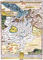
Portal:Maps/Selected biography/17

Erhard Etzlaub, was an astronomer, geodesist, cartographer, instrument maker and physician. From letters from a third party dated 1500 and 1507, we learn that he was a well-known instrument ("compass") maker and a geodesist, and from a letter dated 1517, that "he had also practicised as a physician for at least four years". His death is noted in as the 15th entry in an official list of 20 people buried between December 20, 1531 and February 21, 1532.
On occasion of the Holy Year 1500, when many pilgrims were expected to go to Rome, he designed his famous "Rom-Weg" map, a 41 x 29 cm wood engraving in stereographic projection of app. scale 1:5,6 mio., the earliest printed road map of central Europe. It is, as all of Etzlaub's maps, "South-up". Distances between cities can be computed by dotted lines, where a one-dot-step means one German Mile (7400m). If the prints were coloured, they show political regions, too.
