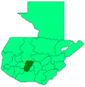
Pochuta
Appearance
Pochuta | |
|---|---|
Municipality and town | |
| Coordinates: 14°32′42″N 91°05′20″W / 14.54500°N 91.08889°W | |
| Country | |
| Department | |
| Government | |
| • Major (2016-2020) | Héctor R. Hernández Cumar[1] |
| Area | |
• Total | 70 sq mi (170 km2) |
| Elevation | 3,005 ft (916 m) |
| Time zone | UTC+6 (Central Time) |
Pochuta is a municipality in the Chimaltenango department of Guatemala.
History and general information
[edit]The town was known as "San Miguel Pochuta" during the Spanish colony and was elevated to a municipality in 1921. It has an area of 170 km2 and its municipal capital sits at 916 m above sea level. The main religious annual celebrations are in September, after Michael Archangel.
Name origin
[edit]"Pochuta" comes from the nahuatl Pochotl or Pochotla, which means "Place of ceibas".
Geographic location
[edit]Pochuta is surrounded by Chimaltenango Department municipalities except on the west, where it borders San Lucas Tolimán, a Sololá Department municipality:[2]
See also
[edit]References
[edit]- ^ "Partido UNE gana alcaldía de Chimaltenango". Prensa Libre (in Spanish). Guatemala. 8 September 2015. Retrieved 8 September 2015.
- ^ a b c SEGEPLAN (2010). "Municipios de Chimaltenango" (in Spanish). Guatemala. Archived from the original on 8 June 2015. Retrieved 8 June 2015.


