Pigra
Appearance
Pigra | |
|---|---|
| Comune di Pigra | |
| Coordinates: 45°57′N 9°7′E / 45.950°N 9.117°E | |
| Country | Italy |
| Region | Lombardy |
| Province | Province of Como (CO) |
| Area | |
• Total | 4.3 km2 (1.7 sq mi) |
| Elevation | 881 m (2,890 ft) |
| Population (Dec. 2004)[2] | |
• Total | 294 |
| • Density | 68/km2 (180/sq mi) |
| Time zone | UTC+1 (CET) |
| • Summer (DST) | UTC+2 (CEST) |
| Postal code | 22020 |
| Dialing code | 031 |

Pigra is a comune (municipality) in the Province of Como in the Italian region Lombardy, located about 50 kilometres (31 mi) north of Milan and about 15 kilometres (9 mi) north of Como. Located at 881 metres (2,890 ft) above sea level, with a panoramic view on Lake Como, the town is accessible by paved road from Argegno, winds along the Valle d'Intelvi and by cable railway, which in five minutes exceeds a drop of 540 metres (1,770 ft), allowing access to the village directly from Argegno. As of 31 December 2004, it had a population of 294 and an area of 4.3 square kilometres (1.7 sq mi).[3]
Pigra borders the following municipalities: Argegno, Blessagno, Colonno, Dizzasco, Laino.
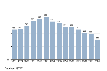
Demographic evolution
[edit]
References
[edit]- ^ "Superficie di Comuni Province e Regioni italiane al 9 ottobre 2011". Italian National Institute of Statistics. Retrieved 16 March 2019.
- ^ "Popolazione Residente al 1° Gennaio 2018". Italian National Institute of Statistics. Retrieved 16 March 2019.
- ^ All demographics and other statistics: Italian statistical institute Istat.


