Paulson, Manitoba
Appearance
Paulson | |
|---|---|
| Coordinates: 51°6′55″N 99°55′58″W / 51.11528°N 99.93278°W[1] | |
| Country | Canada |
| Province | Manitoba |
| Municipality | RM of Dauphin |
| Region | Parkland |
| Elevation | 287 m (942 ft) |
| Time zone | UTC-6 (CST) |
| • Summer (DST) | UTC-5 (CDST) |
| Area code | 204 |
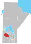
Paulson is a locality in Manitoba, Canada.[1] It is located 9 kilometres (6 mi) southeast of Dauphin and 186 miles (299 km) northwest of Winnipeg.
Paulson lies within the Rural Municipality of Dauphin.
Royal Canadian Air Force
[edit]RCAF Station Paulson was the site of British Commonwealth Air Training Plan No. 7 Bombing & Gunnery School during World War II.[3]
References
[edit]- ^ a b "Paulson". Geographical Names Data Base. Natural Resources Canada. Retrieved June 13, 2012.
- ^ At geographic coordinates, per Google Earth
- ^ Hatch, F. J. (1983). The Aerodrome of Democracy: Canada and the British Commonwealth Air Training Plan, 1939-1945 (PDF). Ottawa: Directorate of History, Department of National Defence. p. 205. ISBN 0-660-11443-7. Archived from the original (PDF) on February 11, 2014. Retrieved June 2, 2019.


