Paraparaumu Beach
Paraparaumu Beach | |
|---|---|
Town | |
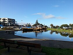
 Paraparaumu Beach in 2013 | |
 | |
| Coordinates: 40°53′38″S 174°58′46″E / 40.893777°S 174.979437°E | |
| Country | New Zealand |
| Region | Wellington Region |
| Territorial authority | Kāpiti Coast District |
| Ward | Paraparaumu Ward |
| Community | Paraparaumu Community |
| Electorates | |
| Government | |
| • Territorial Authority | Kāpiti Coast District Council |
| • Regional council | Greater Wellington Regional Council |
| • Kāpiti Coast Mayor | Janet Holborow |
| • Ōtaki MP | Tim Costley |
| • Te Tai Hauāuru MP | Debbie Ngarewa-Packer |
| Area | |
• Total | 5.12 km2 (1.98 sq mi) |
| Population (June 2024)[2] | |
• Total | 9,610 |
| • Density | 1,900/km2 (4,900/sq mi) |
| Postcode(s) | 5032 |
| Area code | 04 |
Paraparaumu Beach is a coastal settlement on the Kāpiti Coast of New Zealand's North Island. It is located west of the main Paraparaumu township, 50 km (31 mi) north of Wellington. The area faces Kapiti Island.
Demographics
[edit]Paraparaumu Beach covers 5.12 km2 (1.98 sq mi)[1] and had an estimated population of 9,610 as of June 2024,[2] with a population density of 1,877 people per km2.
| Year | Pop. | ±% p.a. |
|---|---|---|
| 2006 | 8,010 | — |
| 2013 | 8,580 | +0.99% |
| 2018 | 9,087 | +1.15% |
| Source: [3] | ||
Before the 2023 census, Paraparaumu Beach had a smaller boundary, covering 4.80 km2 (1.85 sq mi).[1] Using that boundary, Paraparaumu Beach had a population of 9,087 at the 2018 New Zealand census, an increase of 507 people (5.9%) since the 2013 census, and an increase of 1,077 people (13.4%) since the 2006 census. There were 3,609 households, comprising 4,293 males and 4,794 females, giving a sex ratio of 0.9 males per female, with 1,629 people (17.9%) aged under 15 years, 1,287 (14.2%) aged 15 to 29, 3,921 (43.1%) aged 30 to 64, and 2,250 (24.8%) aged 65 or older.
Ethnicities were 89.9% European/Pākehā, 11.8% Māori, 2.7% Pasifika, 4.5% Asian, and 2.5% other ethnicities. People may identify with more than one ethnicity.
The percentage of people born overseas was 23.4, compared with 27.1% nationally.
Although some people chose not to answer the census's question about religious affiliation, 53.7% had no religion, 35.5% were Christian, 0.3% had Māori religious beliefs, 0.6% were Hindu, 0.2% were Muslim, 0.5% were Buddhist and 1.6% had other religions.
Of those at least 15 years old, 1,491 (20.0%) people had a bachelor's or higher degree, and 1,230 (16.5%) people had no formal qualifications. 1,401 people (18.8%) earned over $70,000 compared to 17.2% nationally. The employment status of those at least 15 was that 3,270 (43.8%) people were employed full-time, 1,059 (14.2%) were part-time, and 303 (4.1%) were unemployed.[3]
| Name | Area (km2) |
Population | Density (per km2) |
Households | Median age | Median income |
|---|---|---|---|---|---|---|
| Paraparaumu Beach North | 2.14 | 4,056 | 1,895 | 1,482 | 42.1 years | $32,300[4] |
| Paraparaumu Beach West | 1.59 | 2,364 | 1,487 | 1,017 | 50.5 years | $31,400[5] |
| Paraparaumu Beach East | 1.07 | 2,667 | 2,493 | 1,110 | 49.9 years | $27,900[6] |
| New Zealand | 37.4 years | $31,800 |
The demographics for Paraparaumu Beach are also incorporated in Paraparaumu#Demographics.
Attractions
[edit]Attractions include a studio and gallery of artist Shona Moller and Paraparaumu Beach Golf Club,[7] as well as newly refurbished MacLean Park area, the Saturday Market on MacLean Street, the shops around the area, and the Kapiti Boating Club.
Especially after World War II, the Paraparaumu Beach shops were a popular weekend destination. At the time, shops had restrictions preventing them from opening in the weekends, but places such Paraparaumu Beach were allowed to open.[8]
Education
[edit]Paraparaumu Beach School is a co-educational state primary school for Year 1 to 8 students,[9][10] with a roll of 542 as of November 2024.[11]
Kenakena School is a co-educational state primary school for Year 1 to 8 students,[12][13] with a roll of 591.[14]
Paraparaumu College is a co-educational state secondary school for Year 9 to 13 students,[15][16] with a roll of 1,407 as of November 2024.[17]
References
[edit]- ^ a b c "ArcGIS Web Application". statsnz.maps.arcgis.com. Retrieved 28 March 2024.
- ^ a b "Aotearoa Data Explorer". Statistics New Zealand. Retrieved 26 October 2024.
- ^ a b "Statistical area 1 dataset for 2018 Census". Statistics New Zealand. March 2020. Paraparaumu Beach North (237000), Paraparaumu Beach West (237100) and Paraparaumu Beach East (237300).
- ^ 2018 Census place summary: Paraparaumu Beach North
- ^ 2018 Census place summary: Paraparaumu Beach West
- ^ 2018 Census place summary: Paraparaumu Beach East
- ^ "Home - Paraparaumu Beach Golf Club". www.paraparaumubeachgolfclub.co.nz. Retrieved 21 December 2019.
- ^ "Paraparaumu Beach stores, 1940s". teara.govt.nz. Retrieved 14 July 2023.
- ^ "Paraparaumu Beach School Official School Website". paraparaumubeach.school.nz.
- ^ "Paraparaumu Beach School Ministry of Education School Profile". educationcounts.govt.nz. Ministry of Education.
- ^ "Paraparaumu Beach School Education Review Office Report". ero.govt.nz. Education Review Office.
- ^ "Kenakena School Official School Website". kenakena.school.nz.
- ^ "Kenakena School Ministry of Education School Profile". educationcounts.govt.nz. Ministry of Education.
- ^ "Kenakena School Education Review Office Report". ero.govt.nz. Education Review Office.
- ^ "Paraparaumu College Official School Website". paraparaumucollege.school.nz.
- ^ "Paraparaumu College Ministry of Education School Profile". educationcounts.govt.nz. Ministry of Education.
- ^ "Paraparaumu College Education Review Office Report". ero.govt.nz. Education Review Office.
