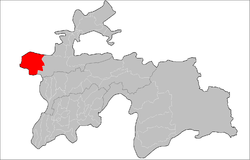
Panjakent District
Appearance
Panjakent District | |
|---|---|
 Location of Panjakent District in Tajikistan | |
| Country | |
| Region | Sughd Region |
| Capital | Panjakent |
| Population | |
• Total | 230,000 |
| Time zone | UTC+5 (TJT) |
| Official languages | |
Panjakent District or Nohiya-i Panjakent (Russian: Пенджикентский район; Tajik: Ноҳияи Панҷакент) is a former district in Sughd Region, Tajikistan. Its capital was Panjakent. Around 2018, it was merged into the city of Panjakent.
Administrative divisions
[edit]The district was divided administratively into jamoats. They were as follows (and population).[1]
| Jamoats of Panjakent District | |||||||||||
| Jamoat | Population | ||||||||||
|---|---|---|---|---|---|---|---|---|---|---|---|
| Amondara | 10486 | ||||||||||
| Chinor | 5384 | ||||||||||
| Farob | 6188 | ||||||||||
| Khalifa Hassan | |||||||||||
| Khurmi | 7943 | ||||||||||
| Kolkhozchiyon | 14416 | ||||||||||
| Kosatarosh | 14421 | ||||||||||
| Mughiyon | 15271 | ||||||||||
| Rudaki | 15059 | ||||||||||
| Sarazm | |||||||||||
| Shing | 9595 | ||||||||||
| Sujina | 10253 | ||||||||||
| Voru | 9968 | ||||||||||
| Yori | |||||||||||
Notes
[edit]References
[edit]- ^ "List of Jamoats". UN Coordination, Tajikistan. Archived from the original on February 13, 2012. Retrieved April 4, 2009.

