Pa Sak, Chiang Rai
Appearance
Pa Sak
ป่าสัก | |
|---|---|
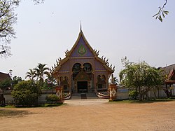
 Wat Ban Pang Mo Puang | |
 | |
| Country | |
| Province | Chiang Rai |
| Amphoe | Chiang Saen |
| Population (2019) | |
• Total | 7,877 |
| Time zone | UTC+7 (TST) |
| Postal code | 57150 |
| TIS 1099 | 570802 |
Pa Sak (Thai: ป่าสัก) is a tambon (subdistrict) of Chiang Saen District, in Chiang Rai Province, Thailand. In 2019 it had a total population of 7,877 people.[1]
History
[edit]The subdistrict was created effective September 15, 1979 by splitting off 9 administrative villages from Si Don Mun.[2]
Administration
[edit]Central administration
[edit]The tambon is subdivided into 13 administrative villages (muban).
| No. | Name | Thai |
|---|---|---|
| 1. | Ban Mae Kham Kaset | บ้านแม่คำเกษตร |
| 2. | Ban Mae Kham Nong Bua | บ้านแม่คำหนองบัว |
| 3. | Ban Pa Sak Noi | บ้านป่าสักน้อย |
| 4. | Ban Pa Daet | บ้านป่าแดด |
| 5. | Ban Nong Bua Sot | บ้านหนองบัวสด |
| 6. | Ban Pang Mo Puang | บ้านปางหมอปวง |
| 7. | Ban Doi Champi | บ้านดอยจำปี |
| 8. | Ban Doi Si Kaeo | บ้านดอยศรีแก้ว |
| 9. | Ban San Makhet | บ้านสันมะเค็ด |
| 10. | Ban Doi Kham | บ้านดอยคำ |
| 11. | Ban Mae Kham Tai | บ้านแม่คำใต้ |
| 12. | Ban Pa Sak Noi | บ้านป่าสักน้อย |
| 13. | Ban Pa Sak Noi | บ้านป่าสักน้อย |
Local administration
[edit]The whole area of the subdistrict is covered by the subdistrict administrative organization (SAO) Pa Sak (องค์การบริหารส่วนตำบลป่าสัก).
Landmarks
[edit]The historical site of Wat Pa Sak is located in this region.[3]
References
[edit]- ^ "Population statistics 2019" (in Thai). Department of Provincial Administration. Retrieved 2020-12-17.
- ^ "ประกาศกระทรวงมหาดไทย เรื่อง ตั้งและเปลี่ยนแปลงเขตตำบลในท้องที่อำเภอแม่สาย อำเภอเชียงแสน จังหวัดเชียงราย" (PDF). Royal Gazette (in Thai). 96 (177 ง): 3647–3654. 1979-10-16.[dead link]
- ^ "Wat Pa Sak, Chiang Saen - TripAdvisor". TripAdvisor. Retrieved 2018-11-02.
