Portal:Siberia
The Siberia Portal
A portal dedicated to Siberia
Introduction
Siberia | |
|---|---|
Geographical region | |
 Siberian Federal District |
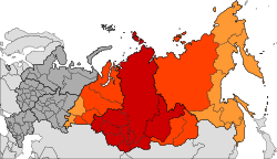
Siberia (/saɪˈbɪəriə/ sy-BEER-ee-ə; Russian: Сибирь, romanized: Sibir', IPA: [sʲɪˈbʲirʲ] ⓘ) is an extensive geographical region comprising all of North Asia, from the Ural Mountains in the west to the Pacific Ocean in the east. It has formed a part of the sovereign territory of Russia and its predecessor states since the centuries-long conquest of Siberia, which began with the fall of the Khanate of Sibir in the late 16th century and concluded with the annexation of Chukotka in 1778. Siberia is vast and sparsely populated, covering an area of over 13.1 million square kilometres (5,100,000 sq mi), but home to roughly a quarter of Russia's population. Novosibirsk, Krasnoyarsk, and Omsk are the largest cities in the area.
Because Siberia is a geographic and historic concept and not a political entity, there is no single precise definition of its territorial borders. Traditionally, Siberia spans the entire expanse of land from the Ural Mountains to the Pacific Ocean, with the Ural River usually forming the southernmost portion of its western boundary, and includes most of the drainage basin of the Arctic Ocean. It is further defined as stretching from the territories within the Arctic Circle in the north to the northern borders of Kazakhstan, Mongolia, and China in the south, although the hills of north-central Kazakhstan are also commonly included. The Russian government divides the region into three federal districts (groupings of Russian federal subjects), of which only the central one is officially referred to as "Siberian"; the other two are the Ural and Far Eastern federal districts, named for the Ural and Russian Far East regions that correspond respectively to the western and eastern thirds of Siberia in the broader sense.
Siberia is known for its long, harsh winters, with a January average of −25 °C (−13 °F). Although it is geographically in Asia, Russian sovereignty and colonization since the 16th century has led to perceptions of the region as culturally and ethnically European. Over 85% of its population are of European descent, chiefly Russian (comprising the Siberian sub-ethnic group), and Eastern Slavic cultural influences predominate throughout the region. Nevertheless, there exist sizable ethnic minorities of Asian lineage, including various Turkic communities—many of which, such as the Yakuts, Tuvans, Altai, and Khakas, are Indigenous—along with the Mongolic Buryats, ethnic Koreans, and smaller groups of Samoyedic and Tungusic peoples (several of whom are classified as Indigenous small-numbered peoples by the Russian government), among many others. (Full article...)
Selected article -
Taiga or tayga (/ˈtaɪɡə/ TY-gə; Russian: тайга́, IPA: [tɐjˈɡa]), also known as boreal forest or snow forest, is a biome characterized by coniferous forests consisting mostly of pines, spruces, and larches. The taiga or boreal forest is the world's largest land biome. In North America, it covers most of inland Canada, Alaska, and parts of the northern contiguous United States. In Eurasia, it covers most of Sweden, Finland, much of Russia from Karelia in the west to the Pacific Ocean (including much of Siberia), much of Norway and Estonia, some of the Scottish Highlands, some lowland/coastal areas of Iceland, and areas of northern Kazakhstan, northern Mongolia, and northern Japan (on the island of Hokkaidō). The principal tree species, depending on the length of the growing season and summer temperatures, vary across the world. The taiga of North America is mostly spruce; Scandinavian and Finnish taiga consists of a mix of spruce, pines and birch; Russian taiga has spruces, pines and larches depending on the region; and the Eastern Siberian taiga is a vast larch forest.
Taiga in its current form is a relatively recent phenomenon, having only existed for the last 12,000 years since the beginning of the Holocene epoch, covering land that had been mammoth steppe or under the Scandinavian Ice Sheet in Eurasia and under the Laurentide Ice Sheet in North America during the Late Pleistocene. (Full article...)
Interesting facts -
- Henry Lansdell (pictured) distributed multi-lingual religious tracts and Bibles in hospitals and prisons in Siberia and central Asia.
- Lisa Cristiani was the first European to hold public musical concerts in Siberia.
- Physicist Kurt Gottfried worked on behalf of Russian dissident Yuri Orlov to obtain his release from Siberia and employment at Cornell University.
General topics
- Prehistory of Siberia
- History of Siberia
- Geography of Siberia
- North Asia § Geography
- Demographics of Siberia
- Indigenous peoples of Siberia
- Category:Flora of Siberia – includes flora taxa that are native to Siberia. Taxa of the lowest rank are always included. Higher taxa are included only if endemic.
- Siberia Governorate
- Siberian Republic
- Great Russian Regions
- Trans-Siberian Railway
Need assistance?

Do you have a question about Siberia that you can't find the answer to? Consider asking it at the Wikipedia reference desk.
General images -
Related portals
WikiProjects
Categories
Trans-Siberian Railway route map
| Trans–Siberian Railway | |||||||||||||||||||||||||||||||||||||||||||||||||||||||||||||||||||||||||||||||||||||||||||||||||||||||||||||||||||||||||||||||||||||||||||||||||||||||||||||||||||||||||||||||||||||||||||||||||||||||||||||||||||||||||||||||||||||||||||||||||||||||||||||||||||||||||||||||||||||||||||||||||||||||||||||||||||||||||||||||||||||||||||||||||||||||||||||||||||||||||||||||||||||||||||||||||||||||||||||||||||||||||||||||||||||||||||||||||||||||||||||||||||||||||||||||||||||||||||||||||||||||||||||||||||||||||||||||||||||||||||||||||||||||||||||||||||||||||||||||||||||||||||||||||||||||||||||||||||||||||||||||||||||||||||||||||||||||||||||||||||||||||||||||||||||||||||||||||||||||||||||||||||||||||||||||||||||||||||||||||||||||||||||||||||||||||||||||||||||||||||||||||||||||||||||||||||||||||||||||||||||||||||||||||||||||||||||||||||||||||||||||||||||||||||||||||||||||||||||||||||||||||||||||||||||||||||||||||||||||||||||||||||||||||||||||||||||||||||||||||||||||||||||||||||||||||||||||||||||||
| |||||||||||||||||||||||||||||||||||||||||||||||||||||||||||||||||||||||||||||||||||||||||||||||||||||||||||||||||||||||||||||||||||||||||||||||||||||||||||||||||||||||||||||||||||||||||||||||||||||||||||||||||||||||||||||||||||||||||||||||||||||||||||||||||||||||||||||||||||||||||||||||||||||||||||||||||||||||||||||||||||||||||||||||||||||||||||||||||||||||||||||||||||||||||||||||||||||||||||||||||||||||||||||||||||||||||||||||||||||||||||||||||||||||||||||||||||||||||||||||||||||||||||||||||||||||||||||||||||||||||||||||||||||||||||||||||||||||||||||||||||||||||||||||||||||||||||||||||||||||||||||||||||||||||||||||||||||||||||||||||||||||||||||||||||||||||||||||||||||||||||||||||||||||||||||||||||||||||||||||||||||||||||||||||||||||||||||||||||||||||||||||||||||||||||||||||||||||||||||||||||||||||||||||||||||||||||||||||||||||||||||||||||||||||||||||||||||||||||||||||||||||||||||||||||||||||||||||||||||||||||||||||||||||||||||||||||||||||||||||||||||||||||||||||||||||||||||||||||||||
External media
Most populated areas

Associated Wikimedia
The following Wikimedia Foundation sister projects provide more on this subject:
-
Commons
Free media repository -
Wikibooks
Free textbooks and manuals -
Wikidata
Free knowledge base -
Wikinews
Free-content news -
Wikiquote
Collection of quotations -
Wikisource
Free-content library -
Wikiversity
Free learning tools -
Wiktionary
Dictionary and thesaurus
More portals


