Bečej
Bečej
| |
|---|---|
Town and municipality | |
|
From top: Town Hall, Old Windmill, Serbian Orthodox Church of Saint George, The Assumption of Blessed Virgin Mary Catholic Church, Fantast Castle, Technical College | |
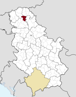
 Location of the municipality of Bečej within Serbia | |
| Coordinates: 45°37′N 20°02′E / 45.617°N 20.033°E | |
| Country | |
| Province | |
| District | South Bačka |
| Settlements | 5 |
| Government | |
| • Mayor | Vuk Radojević (SNS) |
| Area | |
| • Municipality | 487 km2 (188 sq mi) |
| Elevation | 82 m (269 ft) |
| Population (2022 census)[2] | |
| • Town | 19,492 |
| • Municipality | 30,681 |
| Time zone | UTC+1 (CET) |
| • Summer (DST) | UTC+2 (CEST) |
| Postal code | 21220 |
| Area code | +381 21 |
| Car plates | BČ |
| Website | www |
Bečej (Serbian: Бечеј, pronounced [bɛ̌tʃɛːj]; Hungarian: Óbecse, pronounced [ˈoːbɛt͡ʃɛ]) is a town and municipality located in the South Bačka District of the autonomous province of Vojvodina, Serbia. The town has a population of 19,492, while the municipality has 30,681 inhabitants.
History
[edit]Bečej was mentioned first during the administration of the Kingdom of Hungary in 1091 under its Latin name Bechey[3] and later in 1238 under Hungarian name Becse.[citation needed] The name probably originated from the Bechey family that had possessions in this area.[4] In the 15th century (from 1419 to 1441) the town was a possession of the Serbian despot Đurađ Branković. Expecting the upcoming defeat of the Serbian Despotate Đurađ Branković transferred all of his movable assets to Bečej before his death in 1456.[5]
In the end of the 15th century, the army of the Kingdom of Hungary led by Serbian despot Vuk Grgurević (Zmaj Ognjeni Vuk) defeated the Ottoman army near Bečej.[4] In 1551, an Ottoman army led by Mehmed paša Sokolović conquered the town.[4] Bečej was administered by the Ottomans between 1551 and 1687 (nominally to 1699) and was part of the Sanjak of Segedin, which was initially in Budin eyalet, latterly in Eğri Eyalet.[6] In Ottoman Turkish it was known as "Beçe".
In the end of the 17th century the Ottoman administration was replaced by a Habsburg one and the settlement was populated by ethnic Serbs from Banat who had run away from the Ottoman Empire. Between 1702 and 1751, the town belonged to the Tisza-Maros section of the Habsburg Military Frontier. After the abolishment of this part of the Frontier in 1751, many Serbs from the town emigrated to Russia (notably to New Serbia and Slavo-Serbia). They founded a new settlement with name Bečej in New Serbia. To prevent this emigration, the Habsburg authorities formed the autonomous District of Potisje with seat in Bečej. The District of Potisje was in existence between 1751 and 1848. Three privileges were given to the district in 1759, 1774 and 1800 respectively. The first privilege of the District defined its autonomous status, while the second one allowed ethnic Hungarians to settle in the district. In the following period many Hungarians settled in Bečej (the first ones in 1757[7]) and gradually replaced the Serbs as the dominant ethnicity in the town. In 1751, the entire population of the town had been composed of Serbs, while in 1774 half of the population was made up of Serbs and another half was composed of Hungarians.[4] According to the 1910 census, the population of Becse municipality numbered 54,275 people, of whom 30,465 spoke Hungarian and 22,821 Serbian. The town of Bečej had 19,372 inhabitants in 1910, of which 12,488 spoke Hungarian (64.46%), 6,582 Serbian (33.98%) and 193 German (1%).[8]
A Serb elementary school in Bečej was opened in 1703; it is one of the oldest schools in Vojvodina[4] as well as the first elementary school among Serbs.[9] A Hungarian elementary school was opened in Bečej in 1765, while the Jewish elementary school was opened in 1882. A Serb reading house was opened in 1862, and a Hungarian reading house was opened in 1869.
In 1918 Bečej became part of the Kingdom of Serbs, Croats and Slovenes and subsequent South Slavic states. During the Hungarian Axis occupation, in the 1942 raid, 215 inhabitants of the town were murdered by Hungarian forces, of whom 111 were men, 72 women, 13 children, and 19 elders.[10] By nationality, the victims included 110 Jews, 102 Serbs, and 1 Hungarian.[10]
-
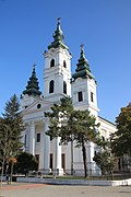
Assumption of Blessed Virgin Mary Catholic Church
-
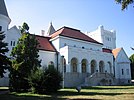
Fantast Castle near Bečej
Inhabited places
[edit]Bečej municipality includes the town of Bečej and the following villages:
- Bačko Gradište (Hungarian: Bácsföldvár)
- Bačko Petrovo Selo (Hungarian: Péterréve)
- Mileševo (Hungarian: Kutaspuszta and Drea)
- Radičević (also known as Čikerija)
Note: for settlements with absolute or relative Hungarian majority names are also given in Hungarian.
There are also several sub-settlements in the municipality, including:
- Poljanice (Hungarian: Pecesor)
- Novo Selo
- Drljan
Demographics
[edit]
| Year | Pop. | ±% p.a. |
|---|---|---|
| 1948 | 42,071 | — |
| 1953 | 43,021 | +0.45% |
| 1961 | 44,585 | +0.45% |
| 1971 | 44,976 | +0.09% |
| 1981 | 44,243 | −0.16% |
| 1991 | 42,685 | −0.36% |
| 2002 | 40,987 | −0.37% |
| 2011 | 37,351 | −1.03% |
| 2022 | 30,681 | −1.77% |
| Source: [11] | ||
According to the 2022 census results, the town of Bečej had 19,492 inhabitants while municipality of Bečej had 30,681 inhabitants.
Ethnic structure
[edit]Bečej is an ethnically mixed town and municipality. There is one settlement with a Serb ethnic majority, Radičević, while town of Bečej and Bačko Gradište have Serb ethnic plurality. Settlements with a Hungarian ethnic majority are Bačko Petrovo Selo and Mileševo.
The ethnic structure of population of town of Bečej (according to the 2022 census):[12]
| Ethnicity | Population | Proportion |
|---|---|---|
| Serbs | 9,098 | 46.67% |
| Hungarians | 7,081 | 36.32% |
| Roma | 210 | 1.07% |
| Others | 751 | 3.85% |
| Undeclared | 1,337 | 6.86% |
| Unknown | 1,015 | 5.20% |
The ethnic structure of population of Bečej municipality (according to the 2022 census):[13]
| Ethnicity | Population | Proportion |
|---|---|---|
| Serbs | 12,996 | 42.35% |
| Hungarians | 12,482 | 40.68% |
| Roma | 877 | 2.85% |
| Others | 1,003 | 3.27% |
| Undeclared | 1,858 | 6.05% |
| Unknown | 1,465 | 4.17% |
Economy
[edit]The following table gives a preview of total number of registered people employed in legal entities per their core activity (as of 2018):[14]
| Activity | Total |
|---|---|
| Agriculture, forestry and fishing | 938 |
| Mining and quarrying | 13 |
| Manufacturing | 2,063 |
| Electricity, gas, steam and air conditioning supply | 62 |
| Water supply; sewerage, waste management and remediation activities | 127 |
| Construction | 190 |
| Wholesale and retail trade, repair of motor vehicles and motorcycles | 1,170 |
| Transportation and storage | 399 |
| Accommodation and food services | 162 |
| Information and communication | 96 |
| Financial and insurance activities | 118 |
| Real estate activities | 11 |
| Professional, scientific and technical activities | 417 |
| Administrative and support service activities | 154 |
| Public administration and defense; compulsory social security | 441 |
| Education | 628 |
| Human health and social work activities | 500 |
| Arts, entertainment and recreation | 81 |
| Other service activities | 145 |
| Individual agricultural workers | 592 |
| Total | 8,307 |
Notable people
[edit]
- Janika Balaž, Romani tamburica musician
- Dejan Perić, Serbian handball player
- Aleksandar Popović Sandor, first Serb geologist
- Carl von Than, Austro-Hungarian chemist
- Mór Than, Hungarian painter
- Aleksandar Maćašev, Serbian artist and designer
- Emeric Feher, French photographer
- Marko Tomićević, Serbian sprint canoer, Olympic silver medalist, World and European champion
- Marko Novaković, Serbian sprint canoer, World and European champion
- Dejan Terzić, Serbian sprint canoer
- Borislava Perić, Serbian table tennis player, Paralympic champion and three-time silver medalist
- Stevan V. Popović, Serbian cultural leader
- Melinda Nadj Abonji, Swiss writer born in Bečej
- Milos Sarcev, IFBB professional bodybuilder and coach
- Slobodan Kalinic, Serbian basketball coach
- Porfirije, Serbian Patriarch
International relations
[edit]Twin towns – Sister cities
[edit]Bečej is twinned with:
Sports
[edit]Bečej is famous for its water polo club VK Bečej which won LEN Champions League in 2000. when the city of Bečej was the host of Final Four.
See also
[edit]- Novi Bečej
- List of cities, towns and villages in Vojvodina
- Fantast Castle, 19th-century castle in the vicinity of Bečej
- Sojaprotein, agribusiness company based in Bečej
References
[edit]- Slobodan Ćurčić, Broj stanovnika Vojvodine, Novi Sad, 1996.
- Zvonimir Golubović, Racija u južnoj Bačkoj 1942. godine, Novi Sad, 1991.
- Jovan Mirosavljević, Brevijar ulica Novog Sada 1745–2001, Novi Sad, 2002.
Footnotes
[edit]- ^ "Municipalities of Serbia, 2006". Statistical Office of Serbia. Retrieved 28 November 2010.
- ^ "2011 Census of Population, Households and Dwellings in the Republic of Serbia: Comparative Overview of the Number of Population in 1948, 1953, 1961, 1971, 1981, 1991, 2002 and 2011, Data by settlements" (PDF). Statistical Office of Republic Of Serbia, Belgrade. 2014. ISBN 978-86-6161-109-4. Retrieved 27 June 2014.
- ^ "Körmendi Ferenc". Szgnye.vmmi.org. Retrieved 26 March 2013.
- ^ a b c d e "Internet prezentacija Beceja i Novog Beceja - Istorija Beceja". Backabanat.com. Retrieved 26 March 2013.
- ^ Dejan Djokić (2023). A Concise History of Serbia. Cambridge University Press. p. 136. ISBN 978-1-107-02838-8.
- ^ "Hungary and Transylvania in 1629". Archived from the original on 27 November 2011. Retrieved 23 May 2011.
- ^ Dr Slobodan Ćurčić, Naselja Bačke - geografske karakteristike, Novi Sad, 2007, page 243.
- ^ Óbecse. Révai nagy lexikona, vol. 14. p. 627. Hungarian Electronic Library. (in Hungarian).
- ^ "Južnobački Okrug Srbija, Vodič kroz Srbiju, Go Serbia goserbia.rs, Srbija na 011info.com". 381info.com. Retrieved 26 March 2013.
- ^ a b Zvonimir Golubović, Racija u Južnoj Bačkoj 1942. godine, Novi Sad, 1992, page 147.
- ^ "2011 Census of Population, Households and Dwellings in the Republic of Serbia" (PDF). stat.gov.rs. Statistical Office of the Republic of Serbia. Archived from the original (PDF) on 14 July 2014. Retrieved 11 January 2017.
- ^ "Попис становништва, домаћинстава и станова 2022. у Републици Србији" (PDF). stat.gov.rs. Republički zavod za statistiku. Retrieved 10 April 2019.
- ^ "Попис становништва, домаћинстава и станова 2022. у Републици Србији" (PDF). stat.gov.rs. Republički zavod za statistiku. Retrieved 10 April 2019.
- ^ "MUNICIPALITIES AND REGIONS OF THE REPUBLIC OF SERBIA, 2019" (PDF). stat.gov.rs. Statistical Office of the Republic of Serbia. 25 December 2019. Retrieved 28 December 2019.


