Lug (Beočin)
Lug
| |
|---|---|
 Village of Lug. | |
| Coordinates: 45°11′0″N 19°32′40″E / 45.18333°N 19.54444°E | |
| Country | |
| Province | Vojvodina |
| District | South Bačka |
| Municipality | Beočin |
| Population (2022) | |
• Total | 529 |
| Time zone | UTC+1 (CET) |
| • Summer (DST) | UTC+2 (CEST) |

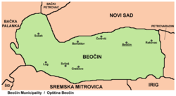
Lug (Serbian Cyrillic: Луг) is a village in western part of the Serbian province of Vojvodina, in the municipality of Beočin, South Bačka District. It lies on the northwest slopes of Fruška gora mountain, in the region of Syrmia. The village has a population numbering 529 people (2022 census), most of them being ethnic Slovaks.
History
[edit]The village originates from the late 19th century, when the local land owner Odescalchi employed people from Bački Petrovac and Gložan, Slovak villages across the Danube, in order to satisfy growing timber export. At first, they resided seasonally and returned to their villages. In order to ensure more permanent work force, they offered them cleared forest land as loan, at the location of the later village. In 1910, the village had 371 residents, and in the mid-century around 500.
Economy
[edit]The residents are mostly engaged in agriculture, with a part working in nearby Beočin.
Culture
[edit]Cultural society "Mladost", with folklore section, maintains the Slovak traditions and dances. The village twice hosted the Slovak cultural festival "Tancuj, tancuj", and their members acted in various folklore festivals across Europe.
Historical population
[edit]- 1961: 764
- 1971: 775
- 1981: 824
- 1991: 864
- 2002: 801
- 2011: 709
- 2022: 529
See also
[edit]References
[edit]- ^ "Статут Општине Беочин, Члан 8" [Beočin Municipality Statute, Article 8] (PDF) (in Serbian). Municipality of Beočin. Retrieved 16 February 2025.
- Slobodan Ćurčić, Broj stanovnika Vojvodine, Novi Sad, 1996.
- "Sremski Slovaci koji govore hrvatski" (in Serbian). Danas. 2007-06-08.
External links
[edit]- "Kulturno-umetničko društvo "Mladost", Lug" (in Slovak).


