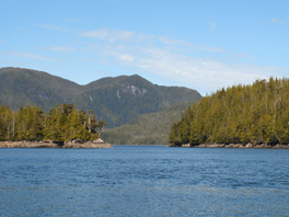
Newcombe Harbour
Appearance
| Newcombe Harbour | |
|---|---|
| Sgasgi’nis (Tsimshian)[1] | |
 Entrance to Newcombe Harbour, off Petrel Channel, part of Pitt Island | |
| Location | British Columbia, Canada |
| Coordinates | 53°42′47″N 130°05′18″W / 53.71306°N 130.08833°W |
| Type | Harbor |
| Part of | Pitt Island |
| Max. length | 0.75 nautical miles (1.39 km; 0.86 mi) |
| Max. width | 0.25 nautical miles (0.46 km; 0.29 mi) |
| Max. depth | 13 fathoms (78 ft; 24 m) |
Newcombe Harbour is a natural harbour located on Pitt Island, British Columbia, Canada. Currently named after Captain Holmes Newcombe who was with the Fisheries Protection Service from 1903 to 1923.[2]
The entrance is 300 feet (91 m) wide, while the body is 0.75 nautical miles (1.39 km; 0.86 mi) long and between 0.0125–0.25 nautical miles (0.0232–0.4630 km; 0.0144–0.2877 mi) wide. The harbor has drying banks at its head, and is surrounded by nine mountains.[3]
Wikimedia Commons has media related to Newcombe Harbour.
References
[edit]- ^ Marsden, Susan (2011). The Gitkxaala, Their History, and Their Territories (Porcher Island, Banks ISland, Pitt Island and Adjacent Islands) (PDF) (Report). p. 55.
- ^ "Newcombe Harbour". BC Geographical Names.
- ^ "Chart 3746, Petrel Channel". Sailing Directions, British Columbia Coast, (Northern Portion). II (Ninth Edition): 259. 1983.

