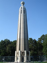
New Durham, Middlesex County, New Jersey
Appearance
New Durham, New Jersey | |
|---|---|
| Coordinates: 40°32′37″N 74°24′22″W / 40.54361°N 74.40611°W | |
| Country | |
| State | |
| County | Middlesex |
| Township | Edison |
| Elevation | 131 ft (40 m) |
| GNIS feature ID | 878731[1] |
New Durham was an unincorporated community and now a neighborhood located within Edison in Middlesex County, New Jersey, United States,[2][3] south of Dismal Swamp.

Along with Piscatawaytown, Bonhamtown, New Dover and Stelton, New Durham is one of the older historical crossroad communities established in Edison (either as once part of Piscataway or Woodbridge before the establishment of Raritan Township, as Edison was earlier known).[4][5] It was described in 1834 as having a tavern, a store, and a half-dozen dwellings.[6]
See also
[edit]References
[edit]- ^ a b "New Durham". Geographic Names Information System. United States Geological Survey, United States Department of the Interior.
- ^ Locality Search, State of New Jersey. Accessed February 11, 2015.
- ^ Spies, Stacy (2001), Edison, Arcadia Publishing, ISBN 9780738505497
- ^ Gannett, Henry (January 28, 1895). "A Geographic Dictionary of New Jersey". U.S. Government Printing Office – via Google Books.
- ^ Gordon, Thomas Francis (1834). "A Gazetteer of the State of New Jersey: Comprehending a General View of Its Physical and Moral Condition, Together with a Topographical and Statistical Account of Its Counties, Towns, Villages, Canals, Rail Roads, &c., Accompanied by a Map".
- ^ Gordon, Thomas Francis (1834). "A Gazetteer of the State of New Jersey: Comprehending a General View of Its Physical and Moral Condition, Together with a Topographical and Statistical Account of Its Counties, Towns, Villages, Canals, Rail Roads, &c., Accompanied by a Map".
Wikimedia Commons has media related to New Durham, Middlesex County, New Jersey.


