Nanjangud
This article needs additional citations for verification. (April 2021) |
Nanjangud
Nanjanagoodu | |
|---|---|
town | |
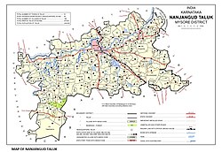
 Nanjangud Taluk Map | |
| Nickname(s): Paddy Land, Dakshina Kaashi | |
 | |
| Coordinates: 12°07′N 76°41′E / 12.12°N 76.68°E | |
| Country | |
| State | Karnataka |
| District | Mysore |
| Elevation | 656 m (2,152 ft) |
| Population (2011)[1] | |
• Total | 61,961 |
| Time zone | UTC+5:30 (IST) |
| PIN | 571 301 |
| Telephone code | 08221 |
| Vehicle registration | KA-09 |
| Website | www.nanjanagudutown.gov.in; http://www.nanjanaguducity.mrc.gov.in |
Nanjangud, officially known as Nanjanagudu, is a town in the Mysuru district of the Indian state of Karnataka. Nanjangud lies on the banks of the river Kapila (also called Kabini), 23 km from the city of Mysore. Nanjangud is famous for the Srikanteshwara Temple located here. Nanjangud is also called Dakshina Kashi (southern Kashi).[2] This town is also famous for a type of banana grown in the region called the Nanjanagoodu rasabale.[3] Nanjangud's local administrative unit was designated as a Municipal Committee in 2015 by including Devirammanahalli and Kallahalli village.[4]
Origin of the name
[edit]The Srikanteshwara Temple at Nanjangud is dedicated to the Hindu deity Shiva, also called Sri Nanjundeshwara (the Lord who drank poison). Nanjanagud means "the place where Nanja (Nanjundeshwara) resides" in Kannada.[2][additional citation(s) needed]
History
[edit]Nanjangud has been a major Shaiva centre for nearly a thousand years. Western Ganga dynasty Kings in the 09th – 10th century are considered to have built this temple with significant additions by the Hoysalas, cholas and the Vijayanagara kings.[5] This temple was later renovated by the Hoysala kings. The Wodeyar kings of Mysore made various grants to renovate the temple.[citation needed]
Geography
[edit]
Nanjangud is located at 15°07′N 76°41′E / 15.12°N 76.68°E.[6] It has an average elevation of 657 metres (2155 ft). The taluk borders Mysore taluk of Mysore district to the north, T Narsipur taluk of Mysore district to the east, H D Kote taluk of Mysore district to the west and Gundlupet and Chamarajanagar taluks of Chamarajanagar district to the south.[citation needed]
Getting there
[edit]Nanjanagud is 24 km from Mysuru and 165 km from Bengaluru Via NH766. Buses are available from Bengaluru, Mysuru city by city bus and Chamarajanagar. The nearest airport is Mysore Airport situated at Mandakalli at a distance of 16 km from Nanjangud and 10 km from Mysuru.
Nanjangud has two railway stations - the Nanjangud Town railway station and the Sujathapuram railway station. Usually only slow trains stop here, except the Chamarajanagar-Tirupati express train.
Notable locations
[edit]Nanjundeshwara Temple
[edit]
This temple is the most famous attraction of the town. It is believed that sage Gauthama stayed here for some time and installed a Linga, the idol form of Shiva.[3]
Parashurama Kshetra
[edit]Near Nanjangud is the confluence of the Kapila and Kaundinya rivers. This place is termed as Parashurama Kshetra where the sage Parashurama is said to have cleansed himself from the sin of beheading his mother.[3]
Oldest rail/road bridge in India
[edit]
The bridge across the Kabini river has been declared as the oldest bridge with both a railway line and a road by the Government of India. It is located at the entrance of temple town here.[7]
The bridge, built in 1735, is now 283 years old and is declared a Heritage Monument by the Government of India.[8][9]
Guru Dataatreya Swamy Temple
[edit]The Dattaatreya Temple is located near the Chamundeshwari Temple on the banks of River Kapila. The idols of Sri Maha Sharabheshwara and Sri Pratyangira Devi are also installed in this temple.[10]
Hemmaragala Santhana Gopala Swamy Temple
[edit]This temple is also known as Hemmaragala Huchu Gopala Santhana Venugopala Swamy or Koundinya Maharshi Kshetra.[11] It is located 13.3 km from the main Nanjangud Srikanteshwara temple. The main idol is called Tribhangi Kolalu Gopala. It is believed to be around 1800 years old and believed to grant children to childless couples. In the temple there are columns and pillars depicting the architecture of Vijayanagara era.[12]
Other attractions
[edit]Scenic places within a 100 km radius of Nanjangud include Bandipur National Park, Shivsamudra Falls and the Kabini Reservoir.[3][13]
Economy
[edit]Nanjangud is home to many industries which are mainly located in the Nanjangud Industrial Area which is spread across 534 acres (2.16 km2). It all started with the now closed Sujatha Textile Mills (STM) which at its peak used to employ about 3000 people. Since then, STM has closed down. However, there are other industries which thrived. There are 36 major industries, 12 medium industries and 35 small-scale units at Nanjangud. According to NIA, Nanjangud is the second highest tax-paying (sales tax of over Rs 400 crore a year) taluk in the State after Bangalore.[citation needed]
Sports
[edit]Football player N.S.Manju is originally from Nanjangud.[citation needed]
Nanjanagudu Banana
[edit]
Nanjangud Rasabaale is a popular variety of the banana fruit, originating from the Devarasanahalli Village. The Nanjanagudu banana has been accorded Geographical Indication tag(GI), number 29.[14][15] Kayyar Kinhanna Rai has authored a famous Kannada poem on the banana titled "Hannu Maruvavana Haadu".[3]
Image gallery
[edit]-
Ambedkar Circle
-
Vivekananda Park
-
Mahadeshara Temple
-
Nanjangud Ground
-
Court
-
Sri Sathyanarayana Temple
-
Paddy fields at Nanjangud
-
Statue of Lord Shiva, near Srikanteshwara Temple
Location
[edit]See also
[edit]References
[edit]- ^ "Census of India Search details". censusindia.gov.in. Retrieved 10 May 2015.
- ^ a b "Nanjangud Town Municipal Council, Karnataka". Nanjangud Town Municipal Council. Archived from the original on 2 August 2013. Retrieved 25 July 2013.
- ^ a b c d e "Nanjangud". Retrieved 28 August 2012.
- ^ "Gazette Notification" (PDF).
- ^ "Official Site of Gov of Karnataka".
- ^ "Falling Rain Genomics, Inc - Nanjangud". Fallingrain.com. Retrieved 16 September 2012.
- ^ "Karnataka Today". karnatakatoday.com.
- ^ "WebHost4Life | Web Hosting, Unix Hosting, E-Mail, Web Design". ourkarnataka.com. Retrieved 1 May 2016.
- ^ "Samyuktha Harshitha: The oldest Railway bridge". samharshbangalore.blogspot.in. 19 January 2013. Retrieved 1 May 2016.
- ^ "Guru Dattaatreya Swamy Temple, Nanjangud | Nanjangud.Info". nanjangud.info. Retrieved 1 May 2016.
- ^ Hemmaragala Huchu Gopala Santhana Venugopal Swamy Nanjangud Karnataka tourism, archived from the original on 13 December 2021, retrieved 22 November 2019
- ^ "Temples of Karnataka - Hemmaragala - Sri.Venugopala Temple". templesofkarnataka.com. Retrieved 22 November 2019.
- ^ "Devanur Dasoha Mutt - Devanuru Village, Nanjangud Taluk". wikimapia.org. Retrieved 1 May 2016.
- ^ Prakash, Rakesh (11 April 2008). "K'taka gets highest number of GI tags | Business Standard News". Business Standard India. business-standard.com. Retrieved 1 May 2016.
- ^ List of Geographical Indications in India


