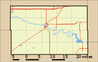
Module:Location map/data/USA Kansas Ellsworth County
Appearance
| name | Ellsworth County, Kansas | |||
|---|---|---|---|---|
| border coordinates | ||||
| 38.914 | ||||
| -98.561 | ←↕→ | -97.851 | ||
| 38.468 | ||||
| map center | 38°41′28″N 98°12′22″W / 38.691°N 98.206°W | |||
| image | Location Map USA Kansas Ellsworth County.svg
| |||

| ||||
Module:Location map/data/USA Kansas Ellsworth County is a location map definition used to overlay markers and labels on an equirectangular projection map of the U.S. County of Ellsworth, Kansas. The markers are placed by latitude and longitude coordinates on the default map or a similar map image.
Usage
These definitions are used by the following templates when invoked with parameter "USA Kansas Ellsworth County":
{{Location map|USA Kansas Ellsworth County |...}}{{Location map many|USA Kansas Ellsworth County |...}}{{Location map+|USA Kansas Ellsworth County |...}}{{Location map~|USA Kansas Ellsworth County |...}}
Map definition
name = Ellsworth County, Kansas- Name used in the default map caption
image = Location Map USA Kansas Ellsworth County.svg- The default map image, without "Image:" or "File:"
top = 38.914- Latitude at top edge of map, in decimal degrees
bottom = 38.468- Latitude at bottom edge of map, in decimal degrees
left = -98.561- Longitude at left edge of map, in decimal degrees
right = -97.851- Longitude at right edge of map, in decimal degrees
Precision
Longitude: from West to East this map definition covers 0.71 degrees.
- At an image width of 200 pixels, that is 0.0036 degrees per pixel.
- At an image width of 1000 pixels, that is 0.0007 degrees per pixel.
Latitude: from North to South this map definition covers 0.446 degrees.
- At an image height of 200 pixels, that is 0.0022 degrees per pixel.
- At an image height of 1000 pixels, that is 0.0004 degrees per pixel.
Examples using location map templates
Location map
{{Location map | USA Kansas Ellsworth County
| width   = 200
| coordinates = {{coord|38.695546|-98.103041|display=inline,title}}
| label   = Faris Caves
}}
See also
Location map templates
- Template:Location map, to display one mark and label using latitude and longitude
- Template:Location map many, to display up to nine marks and labels
- Template:Location map+, to display an unlimited number of marks and labels
Creating new map definitions

