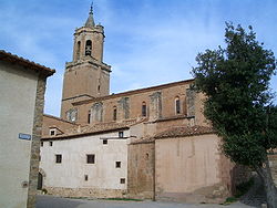
Miravete de la Sierra
Appearance
(Redirected from Miravete de la Sierra, Spain)
This article needs additional citations for verification. (May 2024) |
Miravete de la Sierra | |
|---|---|
 | |
| Coordinates: 40°35′N 0°42′W / 40.583°N 0.700°W | |
| Country | Spain |
| Autonomous community | Aragon |
| Province | Teruel |
| Municipality | Miravete de la Sierra |
| Area | |
| • Total | 36 km2 (14 sq mi) |
| Elevation | 1,218 m (3,996 ft) |
| Population (2018)[1] | |
| • Total | 35 |
| • Density | 0.97/km2 (2.5/sq mi) |
| Time zone | UTC+1 (CET) |
| • Summer (DST) | UTC+2 (CEST) |
Miravete de la Sierra is a municipality located in the province of Teruel, Aragon, Spain. According to the 2004 census (INE), the municipality has a population of 12 inhabitants. However, interviews with local inhabitants establish that the total permanent population in winter is 47 people (according to the 2007 census); while during the summer and other holidays, many more people live there.
References
[edit]- ^ Municipal Register of Spain 2018. National Statistics Institute.
External links
[edit]- El pueblo en el que nunca pasa nada (official Spanish language website)
- Radio interview (in Spanish) with one of the town's inhabitants, where she rebukes the "12 inhabitants" myth.


