Maurha
Appearance
| Maurha Estate | |||||||
|---|---|---|---|---|---|---|---|
| Taluqdar of British India | |||||||
| c. 1894–1948 | |||||||
| History | |||||||
• Established | c. 1894 | ||||||
| 1948 | |||||||
| |||||||
| Today part of | India | ||||||
Maurha | |
|---|---|
Village | |
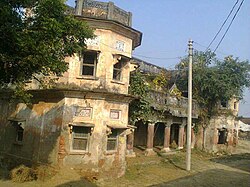
 Maurha Fort | |
| Coordinates: 26°03′13″N 83°55′07″E / 26.053624°N 83.918529°E | |
| Country | |
| State | Uttar Pradesh |
| District | Ballia |
| Founded by | Raja Mohar Singh |
| Government | |
| • Body | Gram panchayat |
| Population (2011) | |
• Total | 555 |
| Languages | |
| • Official | Hindi and Bhojpuri |
| Time zone | UTC+5:30 (IST) |
| PIN | 221718 |
| Vehicle registration | UP |
| Website | up |
Maurha is a village and a Gram panchayat in Ballia district in the Indian state of Uttar Pradesh. Its population is 555, per the 2011 Census.[1] Maurha's nearest railway station is Belthara Road. During British India it was a Taluqdari
Maurha has an ancient temple of Lord Shiva on its outskirts, which is believed to have been constructed in the 16th century AD.
References
[edit]External links
[edit]


