Maskowski District
Appearance
Maskowski District
| |
|---|---|
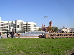
 Independence Square | |
|
Coat of arms | |
 | |
| Coordinates: 53°57′04″N 27°30′37″E / 53.9510°N 27.5102°E | |
| Country | Belarus |
| Municipality | Minsk |
| Area | |
• Total | 30 km2 (10 sq mi) |
| Population (2023)[1] | |
• Total | 308,754 |
| • Density | 10,000/km2 (27,000/sq mi) |
| District number | 8 |
| Website | Official website |
Maskowski District or Maskoŭski District[2] (Belarusian: Маскоўскі раён, romanized: Maskowski rajon; Russian: Московский район, romanized: Moskovsky rayon) is an administrative division of the city of Minsk, the capital of Belarus. It was named after the city of Moscow.[3] As of 2023, it has a population of 308,754.[1]
Geography
[edit]The district is situated in central and south-western area of the city and borders with Frunzyenski, Tsentralny, Leninsky and Kastrychnitski districts.
Transport
[edit]Maskowski is served by the subway and tram networks. It is also crossed by the MKAD beltway.
See also
[edit]References
[edit]- ^ a b "Численность населения на 1 января 2023 г. и среднегодовая численность населения за 2022 год по г.Минску в разрезе районов". belsat.gov.by. Archived from the original on 25 May 2023. Retrieved 19 August 2023.
- ^ Official transliteration from Belarusian language (2007)
- ^ (in Russian) Moskovsky Raion Archived 2005-11-02 at the Wayback Machine, Minsk administration website
External links
[edit]- (in Russian) Maskowski District official website
- (in Russian) Maskowski District on Minsk website
