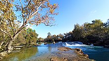
Manavgat Waterfall
Appearance
| Manavgat Waterfall | |
|---|---|
 | |
 | |
| Location | Side, Turkey, Manavgat, Turkey |
| Coordinates | 36°48′49″N 31°27′16″E / 36.81361°N 31.45444°E |
| Type | Waterfall |

Manavgat Waterfall on the Manavgat River is near the city of Side, 3 km (2 mi) north of Manavgat, Turkey. Its high flow over a wide area as it falls from a low height is best viewed from a high altitude.[1]
The white, foaming water of the Manavgat Waterfalls flows powerfully over the rocks. Near the waterfalls are shady tea gardens providing a pleasant resting place.[2]
The Oymapinar Dam is located 12 km (7 mi) to the north of the river.[3]
During floods, the Manavgat Falls may disappear under high water.[4]

The waterfall was depicted on the reverse of the Turkish 5 lira banknotes of 1968–1983.[5]

External links
[edit]References
[edit]- ^ "Manavgat Waterfall". Retrieved 2006-10-30.
- ^ "Altinkaya, Manavgat and Side". Retrieved 2006-10-30.
- ^ "Oymapinar Dam". Archived from the original on 2006-11-14. Retrieved 2006-11-19.
- ^ "AmerasianWorld.com's Manavgat, Turkey". Kevin Miller, Jr. Archived from the original on 2007-06-07. Retrieved 2007-07-07.
- ^ Central Bank of the Republic of Turkey Archived 2009-06-03 at WebCite. Banknote Museum: 6. Emission Group - Five Turkish Lira - I. Series Archived 2009-04-18 at the Wayback Machine & II. Series Archived 2009-02-04 at the Wayback Machine. – Retrieved on 20 April 2009.
Wikimedia Commons has media related to Manavgat Waterfall.

