Maldà
Appearance
Maldà | |
|---|---|
 | |
 Location of Urgell in the region of Catalonia | |
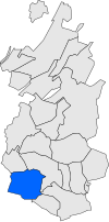
 Location of Maldà in the county of Urgell | |
| Coordinates: 41°33′10″N 1°2′22″E / 41.55278°N 1.03944°E | |
| Country | Spain |
| Region | Catalonia |
| Province | Lleida |
| County | Urgell |
| Government | |
| • Mayor | Josep Maria Batlle Martorell (2019)[1] |
| Area | |
• Total | 31.4 km2 (12.1 sq mi) |
| Elevation | 428 m (1,404 ft) |
| Population (2018)[3] | |
• Total | 225 |
| • Density | 7.2/km2 (19/sq mi) |
| Postal code | 25266 |
| Website | malda |
Maldà is a municipality in the comarca of Urgell, Catalonia, Spain.
Interesting places
[edit]- Castell de Maldà: Medieval castle built in the 13th and 14th centuries.
- Església de Santa Maria: Baroque St. Mary church built in the 18th century.
- Església de Sant Pere: Romanesque St. Peter church of the 12th century.
- Església de Sant Joan de Maldanell: St. Joan of Maldanell church
- Parc de la Font Vella: Leisure and picnic area.
Photo gallery
[edit]-
Maldà's Castle
-
Santa Maria's Church
-
Sant Pere's romanesque Church
-
Sant Joan de Maldanell's Church
-
Maldà after snowing
-
Maldà's pool
See also
[edit]References
[edit]- ^ "Ajuntament de Maldà". Generalitat of Catalonia.
- ^ "El municipi en xifres: Maldà". Statistical Institute of Catalonia. Retrieved 2015-11-23.
- ^ Municipal Register of Spain 2018. National Statistics Institute.
External links
[edit]- Maldà's Council website
- Government data pages (in Catalan)


