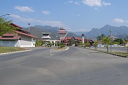
Mae Hong Son Airport
Appearance
This article needs additional citations for verification. (May 2023) |
Mae Hong Son Airport ท่าอากาศยานแม่ฮ่องสอน | |||||||||||
|---|---|---|---|---|---|---|---|---|---|---|---|
 Mae Hong Son airport | |||||||||||
| Summary | |||||||||||
| Airport type | Public | ||||||||||
| Operator | Department of Airports | ||||||||||
| Serves | Mae Hong Son province | ||||||||||
| Location | Chong Kham, Mueang Mae Hong Son, Mae Hong Son, Thailand | ||||||||||
| Opened | 1939 | ||||||||||
| Elevation AMSL | 283 m / 929 ft | ||||||||||
| Coordinates | 19°18′4″N 97°58′29″E / 19.30111°N 97.97472°E | ||||||||||
| Maps | |||||||||||
 | |||||||||||
 | |||||||||||
| Runways | |||||||||||
| |||||||||||
| Statistics (2023) | |||||||||||
| |||||||||||
Sources: Department of Airports | |||||||||||
Mae Hong Son Airport (IATA: HGN, ICAO: VTCH) is in Chong Kham subdistrict, Mueang Mae Hong Son district, Mae Hong Son province in northern Thailand. It has two main buildings, one each for departing and arriving guests.[1] It contains a convenience store, coffee shop, restaurant, souvenir shop, ATM, as well as a parking garage.
Airlines and destinations
[edit]The airport offers both regular flights and helicopter services. It is served by Bangkok Airways.[1]
| Airlines | Destinations |
|---|---|
| Bangkok Airways | Bangkok–Suvarnabhumi, Lampang[2] |
References
[edit]- ^ a b "Mae Hong Son Airport". domesticflightsthailand.com. Retrieved 2023-05-25.
- ^ "Bangkok Airways Resumes Mae Hong Son Service From August 2023". Aeroroutes. Retrieved 26 June 2023.
External links
[edit] Mae Hong Son travel guide from Wikivoyage
- Mae Hong Son Airport, Dept of Civil Aviation
- Current weather for VTCH at NOAA/NWS

