Madulce Peak
Appearance
| Madulce Peak | |
|---|---|
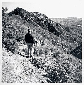
 Hikers en route to Madulce Peak in 1963. Madulce Peak is the highest point on the left. | |
| Highest point | |
| Elevation | 6,539 ft (1,993 m) NAVD 88[1] |
| Prominence | 896 ft (273 m)[1] |
| Listing | Hundred Peaks Section[2] |
| Coordinates | 34°41′27″N 119°35′28″W / 34.690957°N 119.591151°W[3] |
| Geography | |
 | |
| Location | Santa Barbara County, California, U.S. |
| Parent range | San Rafael Mountains |
| Topo map | USGS Madulce Peak |
| Climbing | |
| Easiest route | Hike, Madulce Peak Trail[2] |
Madulce Peak is a mountain located in the San Rafael Mountains, in the Transverse Ranges. It is the highest point of the Dick Smith Wilderness. The summit contains an old fire lookout that was constructed in the 1930s, but was burned down in the 1970s.[4]
Name
[edit]The mountain was originally named Strawberry Peak by surveyors. Over the years, the name "Madulce" was gradually adopted. The Board on Geographic Names originally believed that "madulce" was the Spanish word for "strawberry". Etymological work done by the United States Forest Service ascertained that the word is actually local farmhand slang for "strawberry", from the Catalan word "maduixa".[3][5]
References
[edit]- ^ a b "Madulce Peak, California". Peakbagger.com. Retrieved September 22, 2014.
- ^ a b "Madulce Mountain". Hundred Peaks Section List. Angeles Chapter, Sierra Club. Retrieved September 22, 2014.
- ^ a b "Madulce Peak". Geographic Names Information System. United States Geological Survey, United States Department of the Interior. Retrieved September 22, 2014.
- ^ Carey, Craig (2012). Hiking & backpacking Santa Barbara and Ventura : a complete guide to the trails of the southern Los Padres National Forest. Birmingham, Alabama: Wilderness Press. p. 201. ISBN 0-89997-635-2.
- ^ Draft of a report oh the Madulce Guard Station prepared for the Los Padres National Forest, July, 1978
