Loch Fender
Appearance
| Loch Fender | |
|---|---|
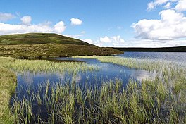
 Meall Dearg rises above the loch 1 Km away. | |
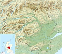
| Location | NN87904131 |
| Coordinates | 56°33′01″N 3°49′30″W / 56.55039978°N 3.82493972°W |
| Type | freshwater loch |
| Max. length | 0.48 km (0.30 mi)[1] |
| Max. width | 0.40 km (0.25 mi)[1] |
| Surface area | 9 ha (22 acres)[2] |
| Average depth | 31.82 ft (9.70 m)[1] |
| Max. depth | 78 ft (24 m)[1] |
| Water volume | 30,998,000 cu ft (877,800 m3)[1] |
| Shore length1 | 1 km (0.62 mi) [2] |
| Surface elevation | 578 m (1,896 ft)[2] |
| Max. temperature | 42.4 °F (5.8 °C) |
| Min. temperature | 36 °F (2 °C) |
| Islands | 0 |
| 1 Shore length is not a well-defined measure. | |
Loch Fender is a small irregular shaped freshwater loch that lies to the north of Loch Freuchie and three miles south-south-east of Amulree and 2+1⁄2 miles from southeast from Milton in Perth and Kinross. For its size it is very deep.[3][1][2]
Geography
[edit]Loch Fender lies midway between Glen Quaich and Glen Cochill in a bowl formed between two small hills, at the top of Glen Fender.
See also
[edit]References
[edit]- ^ a b c d e f John, Murray; Lawrence, Pullar. Bathymetrical Survey of the Fresh-Water Lochs of Scotland, 1897–1909 Lochs of the Tay Basin Volume II – Loch Freuchie. National Library of Scotland. p. 115. Retrieved 10 October 2019.
 This article incorporates text from this source, which is in the public domain.
- ^ a b c d "Loch Fender". Centre for Ecology and Hydrology. Scotland and Northern Ireland Forum for Environmental Research (SNIFFER). Retrieved 13 October 2019.
- ^ Gittings, Bruce; Munro, David. "Fender, Loch". The Gazetteer for Scotland. School of GeoSciences, University of Edinburgh and The Royal Scottish Geographical Society. Retrieved 13 October 2019.

