Lapuz, Iloilo City
Lapuz | |
|---|---|
 | |
 Location within Iloilo City | |
 | |
| Coordinates: 10°42′14″N 122°34′53″E / 10.70389°N 122.58139°E | |
| Country | Philippines |
| Region | Western Visayas (Region VI) |
| Province | Iloilo (geographically only) |
| City | Iloilo City |
| Congressional District | Lone district of Iloilo City |
| Established | July 16, 1937 |
| Incorporated (as district) | December 17, 2008 |
| Barangays | 12 (see Barangays) |
| Government | |
| • Mayor | Jerry Treñas (Mayor of Iloilo City) |
| Area | |
• Total | 3.25 km2 (1.25 sq mi) |
| Population (2020 census) | |
• Total | 31,747 |
| • Density | 9,775.86/km2 (25,319.4/sq mi) |
| Demonym | Lapuznon |
| Time zone | UTC+8 (Philippine Standard Time) |
| ZIP code | 5000 |
| Area code | 33 |
| Native languages | Hiligaynon |
| Patron saint | Nuestra Señora Del Rosario (Our Lady of the Rosary) |
| Feast Day | October 12 |
Lapuz ([laˈpus]) is a district in Iloilo City, Philippines, located in the province of Iloilo, on the island of Panay in the Western Visayas region. It is the smallest district by geographical area as well as the least populous district, with 31,747 people in the 2020 census.
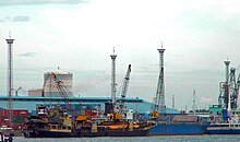
Lapuz is home to many transportation infrastructures that play a vital role in regional connectivity and commerce. The Iloilo International Port Complex (IIPC) serves as a major maritime gateway, facilitating the movement of goods and cargo in and out of Iloilo City.[1]

Lapuz also hosts other seaport terminals, such as the Iloilo Fastcraft and RORO terminals, which serve as terminals for fastcraft and roll-on/roll-off (RORO) vessels, respectively.
Etymology
[edit]The name "Lapuz" is derived from its older name "Lapus-lapus", which came from the Hiligaynon word "lapus", which means "to insert/pass through" because of its location.
History
[edit]Lapuz, initially a sub-district of La Paz during the Spanish regime, eventually gained its own district status on December 17, 2008. Prior to this, Lapuz had been a part of the larger La Paz district within Iloilo City.
The decision to establish Lapuz as a separate district was made by the Sangguniang Panglungsod (City Council) of Iloilo City. This resolution was passed to enable Lapuz to have its own dedicated police station and fire station, ensuring the provision of essential services to the local community.[2]
Geography
[edit]Lapuz is the smallest district, covering 3.25 square kilometres (1.25 sq mi). It is 1.32 kilometres (0.82 mi) from Iloilo City Proper, making it the nearest district to the city center. It's bordered by La Paz to the north and the City Proper to the west. It also faces eastward across the Iloilo Strait at Guimaras Island.
Barangays
[edit]The district of Lapuz has a total of 12 barangays.
- Alalasan
- Bo. Obrero
- Don Esteban
- Jalandoni Estate
- Lapuz Norte
- Lapuz Sur
- Libertad
- Loboc
- Mansaya
- Progreso
- Punong
- Sinikway
See also
[edit]References
[edit]- ^ "Iloilo Ferry Guide: Seaports, Routes, Schedules, RORO". Explore Iloilo. Retrieved August 12, 2022.
- ^ "City to Recognize Lapuz as Separate District from La Paz". The News Today Online. Philippine News Agency. December 22, 2008. Retrieved March 6, 2022.


