L'Orignal
This article has multiple issues. Please help improve it or discuss these issues on the talk page. (Learn how and when to remove these messages)
|


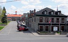
L'Orignal (/ˌlɒrɪnˈjæl/) is a Franco-Ontarian village and former municipality, now part of Champlain Township in eastern Ontario, Canada. Its population in 2016 was 1,450. L'Orignal likely took its name from its location on the Ottawa River once known as Pointe à l'Orignal (French for "Moose Point"), where moose crossed the river. It was one of the seigneuries of New France.
History
[edit]In 1674, the Company of New France granted the Seigneurie de L'Orignac to François Prévost. Through inheritance, the Seigneurie eventually passed on to the de Longueuil family, owners of several seigneuries. It was one of the two seigneuries the King of France granted in present-day Ontario, along with La Salle's Seigneurie de Cataraqui (now Kingston). As part of New France, the area was ceded to Great Britain in 1763. In 1791, with the creation of Upper Canada (Ontario) and Lower Canada (Quebec), the seigneurie became part of Upper Canada.
In 1798, Nathan Treadwell, of Plattsburgh, New York, purchased 230,000 acres (930 km2) of seigneurial land. The government confiscated the property during the War of 1812 and returned it to his son in 1823. In 1816, the Village of L'Orignal was chosen as the district town for the Ottawa District. The Ottawa District Courthouse, built in L'Orignal in 1825, is still in use. The decommissioned L'Orignal Jail is now a museum. L'Orignal Parish was established in 1836 as the first Catholic parish in Prescott County.
The Village was incorporated in 1876 and amalgamated into Champlain Township in 1997 as one of four wards. It is now the county seat of Prescott and Russell United Counties. As of the 2016 census, the population of the former Village of L'Orignal was 1,450.
Geography
[edit]According to Statistics Canada, the former village had a total area of 5.68 square kilometres (2.19 sq mi). It is located at 45 degrees 37' N and 74 degrees 41' W.
References
[edit]External links
[edit] Media related to L'Orignal, Ontario at Wikimedia Commons
- Official website
