Kožljevec
Appearance
Kožljevec | |
|---|---|
 Kožljevec | |
| Coordinates: 45°59′40.25″N 14°42′50.58″E / 45.9945139°N 14.7140500°E | |
| Country | |
| Traditional region | Lower Carniola |
| Statistical region | Central Slovenia |
| Municipality | Grosuplje |
| Area | |
• Total | 1.52 km2 (0.59 sq mi) |
| Elevation | 429.4 m (1,408.8 ft) |
| Population (2002) | |
• Total | 25 |
| [1] | |
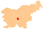
Kožljevec (pronounced [kɔˈʒleːʋəts]; in older sources also Kozljevo,[2] German: Koslewz[2]) is a small settlement in the hills north of Polica in the Municipality of Grosuplje in central Slovenia. The area is part of the historical region of Lower Carniola and is included in the Central Slovenia Statistical Region.[3]
A small roadside chapel-shrine at the village crossroads is dedicated to the Virgin Mary and was built in 1910.[4]
References
[edit]- ^ Statistical Office of the Republic of Slovenia
- ^ a b Leksikon občin kraljestev in dežel zastopanih v državnem zboru, vol. 6: Kranjsko. Vienna: C. Kr. Dvorna in Državna Tiskarna. 1906. p. 102.
- ^ Grosuplje municipal site
- ^ "EŠD 26215". Registry of Immovable Cultural Heritage (in Slovenian). Ministry of Culture of the Republic of Slovenia. Retrieved 30 June 2011.
External links
[edit] Media related to Kožljevec at Wikimedia Commons
- Kožljevec on Geopedia


