
Kamari
Kamari | |
|---|---|
 | |
 | |
| Coordinates: 36°22′36.39″N 25°28′54.58″E / 36.3767750°N 25.4818278°E | |
| Country | Greece |
| Muncipality | Thira |
| Population (2021)[1] | |
• Total | 1,065 |
Kamari (Greek: Καμάρι) is a coastal village on the southeastern part of the Aegean island of Santorini, Greece, in the Cyclades archipelago with a population of 1,065 according to the 2021 census.[1] It is part of the Municipality of Thira and is situated approximately 8 km away from the island's capital Fira. Kamari was built by residents of the nearby village of Episkopi Gonias, which was almost flattened by a devastating earthquake that hit Santorini in July 1956.
The village got its name from a small arch (Greek: Καμάρα, Kamara) that still rises at the south end of its beach and is what remains from an ancient sanctuary dedicated to Poseidon. Today, it stretches along a beach covered with black pebbles, which is the longest of the island. The beach extends in a northeast to southwest direction from Monolithos to the feet of the Mesa vouno mountain that rises up to a height of approx. 400m, being Santorini's second highest peak. Once an agricultural and fishing village, modern Kamari boasts a thriving tourist industry, offering a wide choice of accommodation, restaurants, cafes, bars and night clubs, plus several water sport activities.
In 2002, an archaic sanctuary dedicated to Achilles was discovered in Kamari.
-
 Kamari view from the sea. The peak of Mesa Vouno is on the left, that of Profitis Ilias on the right and the meandering road to Ancient Thera in between.
 -
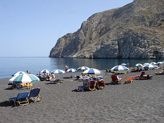 Kamari beach. The arch of Poseidon's sanctuary can be seen near the right edge of the image, right above the sea-level.


See also
[edit]References
[edit]- ^ a b "Αποτελέσματα Απογραφής Πληθυσμού - Κατοικιών 2021, Μόνιμος Πληθυσμός κατά οικισμό" [Results of the 2021 Population - Housing Census, Permanent population by settlement] (in Greek). Hellenic Statistical Authority. 29 March 2024.
External links
[edit]This South Aegean location article is a stub. You can help Wikipedia by expanding it. |