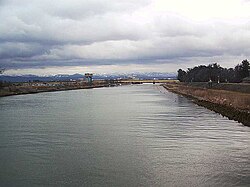
Kakehashi River
Appearance
| Kakehashi River | |
|---|---|
 | |
 | |
| Native name | 梯川 (Japanese) |
| Location | |
| Country | Japan |
| Physical characteristics | |
| Source | |
| • location | Suzugaoka |
| • elevation | 1,174 m (3,852 ft) |
| Mouth | |
• location | Sea of Japan |
| Length | 42 km (26 mi) |
| Basin size | 271 km2 (105 sq mi) |
The Kakehashi River (梯川, Kakehashi-gawa) has its source at Suzugaoka (鈴ヶ丘) in the city of Komatsu, Ishikawa Prefecture, Japan.
Geography
[edit]The river flows from Suzugaoka, which is part of the same mountain chain as Mount Haku.[1] It forms the southern border of Komatsu, separating it from Kaga.
References
[edit]- ^ Kakehashi-gawa Archived 2011-03-26 at the Wayback Machine. Ministry of Land, Infrastructure, Transportation and Tourism. Accessed October 27, 2010.
